
The basic network described in this tutorial consists of nodes, links, and subcatchments, each with many associated data values. Any of these values can be edited using the
 (Properties tool). You can use
Grid Views and Property Sheets to edit object data or change their data flags.
(Properties tool). You can use
Grid Views and Property Sheets to edit object data or change their data flags.
This topic demonstrates a few of the GeoPlan editing tools available in InfoWorks ICM and uses the example network to illustrate how to use them to perform the following operations:
- Using Flags
- Moving Nodes
- Adding Bends to Links
- Reversing Links
Using Flags
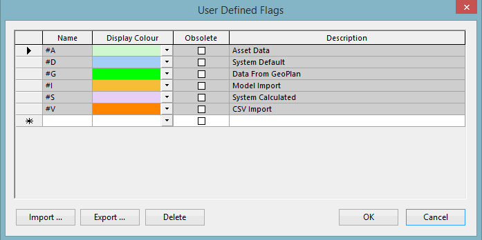
Every item of network data has an associated data flag, which tells you something about how the data was derived. The network already has a number of flags but in this topic, a new flag will be applied to all edited data, which you can then use to indicate the source of your data:
- From the File menu, select the Database management
 User defined flags option.
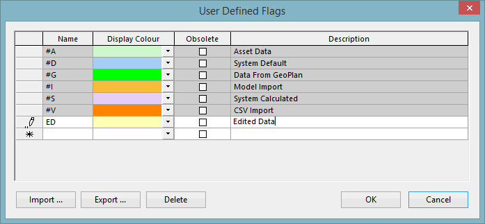
- Click the blank cell at the bottom of the Name column and type in an appropriate flag name. (Note that in the example screenshot in Step 4, we have used 'ED' as the flag name but as the 'ED' flag may already exist on your tutorial database, it is best to create and use a different flag name, e.g. any two capital letters, for this example).
- Click the Display Colour column and select, for example, pale yellow.
- Type 'Edited Data' in the Description column.
- Click OK.
- Set the new flag to be the flag for all editing changes by clicking the
 (Use edit flag) tool and selecting the new flag name in the
 dropdown box to the right. Any data you now change in a Properties window or grid view will automatically have the edited flag attached. Other changes - for example those made with the Move Nodes tool - will not necessarily be given this flag.
The Moving Nodes section demonstrates how to manually set the flags for edited data (this is necessary if the instructions outlined above have not been followed), while the Adding Bends to Links section shows how a built-in flag can be used to automatically update the data.
Moving Nodes
Moving individual nodes
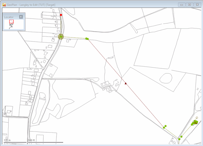
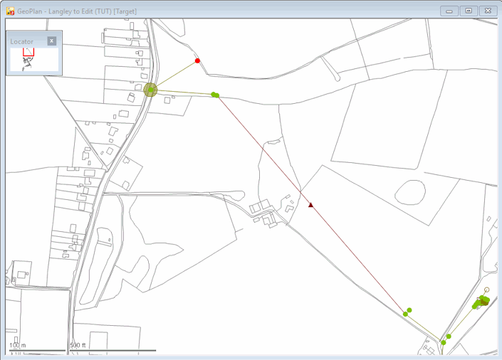
In InfoWorks ICM, it is very easy to move nodes that have been misplaced for some reason. In our example network Node '44635401' is in the wrong position and needs to be moved:
- Use the
 (Find in GeoPlan) tool to zoom to the node.
- Right-click the network, select GIS Layer control and add the 'MapC.shp' layer to the map. If you have not done so, you will need to add the MapC layer. See Working with Background Layers.
- Click OK. The map background is displayed, clearly showing that the node is in the wrong place; the node should be on the same road as the rest of the run of pipes, at coordinates (644499, 263542).
- Select the
 (Edit object geometry) tool and then click the node (do not hold down the mouse button).
- Move the node to the correct coordinates (as shown on the status line) by holding down the left button on your mouse and then release the mouse when you have moved the node to the correct location. The positions of the link connected to the nodes are adjusted, though their length is not changed.
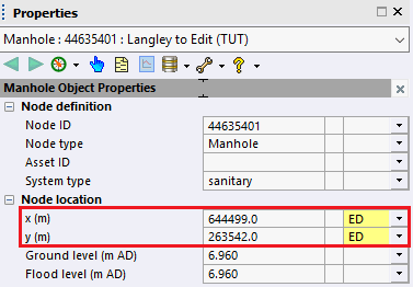
- Use the
(Properties) tool to make sure that the coordinates are correct. (You may have to modify the coordinate values.) Manually change the data flags (in the X and Y fields) to your edited flag (specified in the Using Flags section) on the by clicking the box to the right of the relevant X and Y field and selecting the appropriate option from the dropdown.
- Click
OK to save the changes.
The
Edit object geometry
tool is suitable if the precise position of the node is not critical; otherwise use the Properties sheet.
Moving multiple nodes
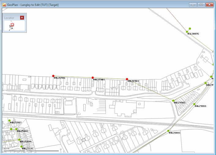
If several nodes need to be moved, the positions for the whole group can be corrected at the same time. The following example illustrates this:
- Click the
 (Clear selection) button to clear any current selection.
- Use the
(Find in GeoPlan) tool to locate node '44629903' and to zoom in on the region upstream of the node.
- Use the Ctrl key with the
 (Selection button) to select the nodes.
- From the Selection menu, choose the Selection operations Geographically Adjust Selection option, and the
Geographical Adjustment of Selection dialog is displayed.
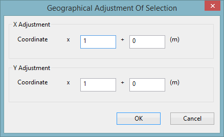
- Type '-40' in the bottom right-hand box.
- Click OK. The nodes are moved to their new positions.
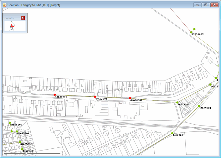
Three nodes have been placed 40 metres too far to the north. They need to be moved south (so that they are just above the road).
The Y coordinate needs to be 40 metres less in each case:
Adding Bends to Links
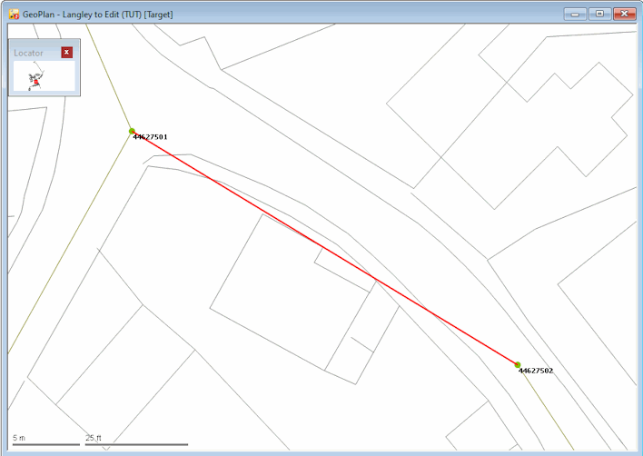
InfoWorks ICM allows you to edit link bends. Links in the model can have bends on the GeoPlan view so they can more closely follow their actual physical position when building a geographically accurate model. An example of how to do so is provided below:
- Use the
(Find in GeoPlan) tool to find and zoom to the link '44627502.1'.
- Select the link. The link must be modified so that it follows the line of the pavement to avoid the building, and then straight to the next node.
- Select the
(Edit object geometry) tool and hold down Ctrl and click the link in two places to add the bends.
- If required, click each of the bends (without pressing Ctrl) and drag them to suitable locations. To remove an intermediate point press ALT and click.
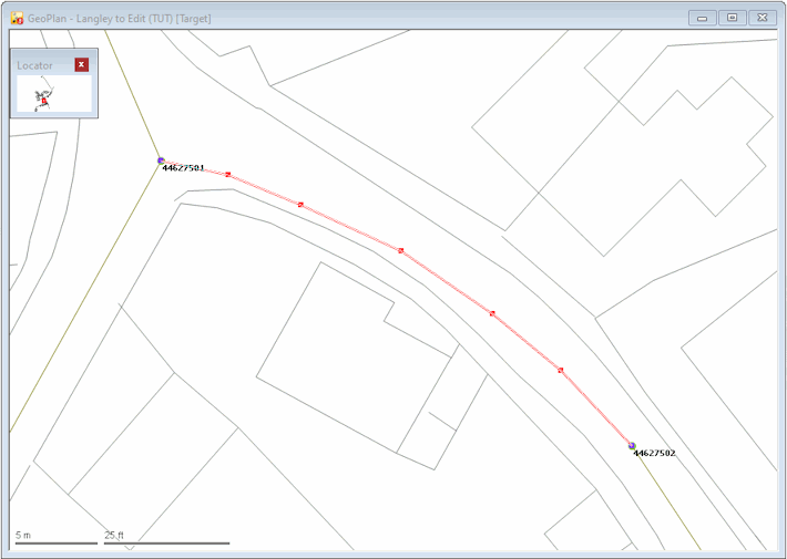
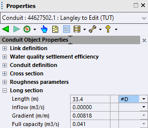
- Click the
(Properties) button and then on the link to display the link's properties on its Properties sheet. The length of the link is no longer accurate but can be updated by changing its data flag.
- Select #D from the dropdown to the right of the Length field. If you do not set the data flag to #D, the Length field must be updated manually.
The #D flag indicates that InfoWorks ICM must automatically calculate the changed length.
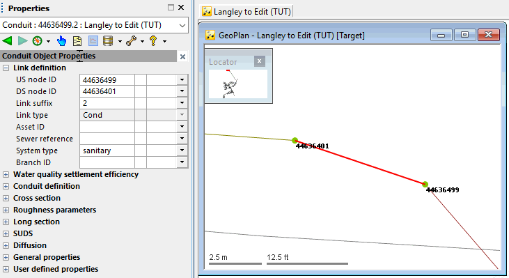
Reversing Links
InfoWorks ICM allows you to reverse the direction of a link if it is incorrect. The
![]() (Trace and select links upstream) and
(Trace and select links upstream) and
 (Trace and select links downstream) tools allow you to check the
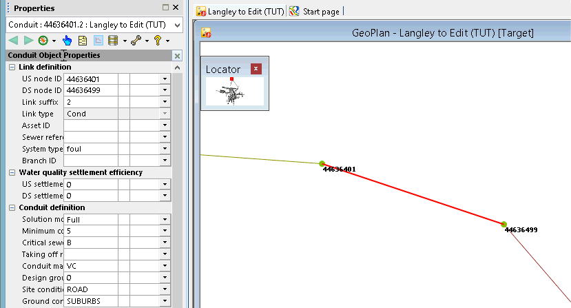
flow direction in your network. The direction of link '44636499.2' is incorrect and needs to be reversed:
(Trace and select links downstream) tools allow you to check the
flow direction in your network. The direction of link '44636499.2' is incorrect and needs to be reversed:
- Right-click the GeoPlan and select the Zoom to network option from the pop-up menu to display the whole network.
- Clear any selection if required. Click the
(Clear selection) button to clear any current selection.
- Zoom in on the region above the pump. Link '44636499.2' is in the wrong direction. You can check this by clicking the
(Properties) button and selecting the link to display its property sheet.
- Select the incorrect link.
- From the
Selection menu, choose Selection operations Reverse links or, click the
 (Reverse all selected links) button, and the ID of the link is changed accordingly. The naming convention for the link ID is US node ID.Link Suffix therefore, the correct ID for this link should be 44636401.2
- If not already displayed, open the Property SheetClick the
(Properties) button and select the link. to check that the change has taken place. Note that the US node ID and DS node ID fields have also been updated accordingly.
- Commit the changes to the network. In the
Explorer window, right-click the icon of the network you opened in Step 1 and select Commit changes from the pop-up menu.
Note that there need to validate the network.
We can now investigate the tools available for simplifying the network.
 Back to flowchart