
This stage introduces the polygon tool, which is used for marking out permanent areas on the network. Using polygons, you can edit a group of objects or move them to another network.
Creating polygons
Polygons can be created on the GeoPlan view:
- Click the
 (New polygon) icon on the Tools toolbar.
- The pointer changes to a
 symbol.
- Mark out the sides of the polygon by clicking where you want the corners to be.
- If the new polygon is directly adjacent to an existing polygon, you can snap individual points to the adjacent polygon, or follow the boundary of the adjacent polygon by snapping a series of points to it. Ensure that snapping mode is switched on if you want to snap points together.
- To finish marking out the polygon, double-click the mouse button. If you want to delete the previously drawn line, press the Backspace key. You can continue to do this to delete each line in turn.
- Once you have finished marking the polygon the Create New Polygon dialog is displayed. Give the polygon a unique ID and select the required type of polygon.
Practical example
The following section illustrates how to use the polygon tool on our network example and shows a few other actions that can be undertaken on a polygon (reshaping a polygon, adjusting values simultaneously for objects of the same type within the polygon, etc.):
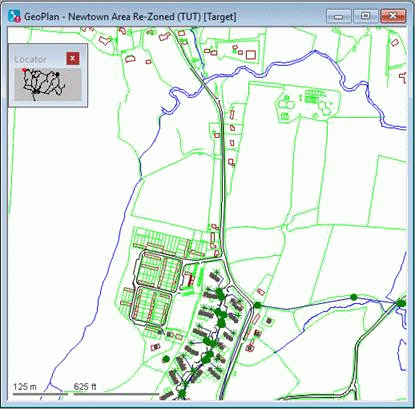
- Create a branch of the 'Newtown Network' network, and give it an appropriate name (for example 'Newtown Area Re-Zoned').
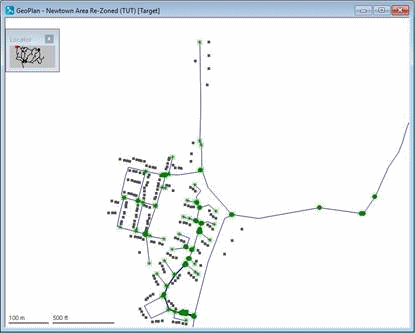
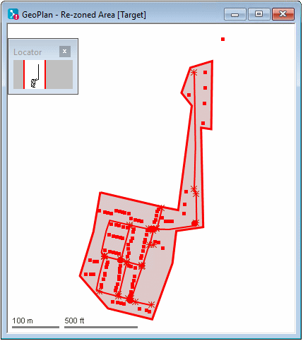
- Zoom in on the north-west of the network. A branch of the network is to be re-zoned, removing it from the current network for inclusion in another network.
- Turn on the Roads, Building and General layers if they are not already turned on.
- Add a polygon:
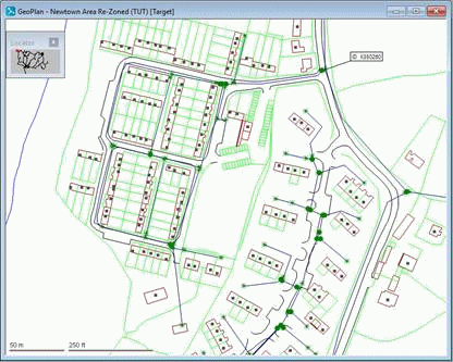
- Zoom in closer, so that you can clearly see the housing estate to the west of K350260.
- Click the
(New Polygon) tool. Mark out an area containing the development area to the west of K350259. If necessary, use the auto-panning feature to include areas not currently visible on the GeoPlan; when the pointer is at the edge of the GeoPlan and turns into a large arrow, click to scroll a short distance in that direction. Double-click to finish the polygon.
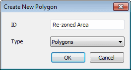
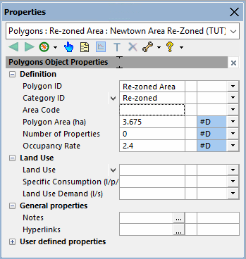
- You are asked for a name. Enter 'Re-zoned Area'. Click
OK.
- In the Definition section of the Polygons properties sheet, click the Category ID drop-down and select
Insert new polygon category object. Enter 'Re-zoned' as the polygon category name and click
OK. The Properties window shows the new category definition properties.
- Use the
 (Select) tool to select the polygon. (Click anywhere inside the polygon). Use
Find selection on the context menu to maximise the display.
(Select) tool to select the polygon. (Click anywhere inside the polygon). Use
Find selection on the context menu to maximise the display.
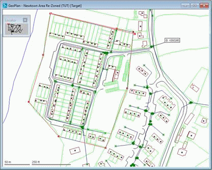
- Use the
 (Reshape polygon) tool to change the polygon boundaries. This time include nodes K350259 and K350260 and all nodes north of that point (as far as K350267). Click the polygon and then drag the polygon corners to new positions. Hold down
Ctrl
and click the polygon border to add new bend points.
When adding further polygons, the points that you add will automatically 'snap' to the corners of nearby polygons, unless you specify otherwise. To turn snap mode off (or back on again) press key S or click the Use Snap Mode button on the toolbar.
(Reshape polygon) tool to change the polygon boundaries. This time include nodes K350259 and K350260 and all nodes north of that point (as far as K350267). Click the polygon and then drag the polygon corners to new positions. Hold down
Ctrl
and click the polygon border to add new bend points.
When adding further polygons, the points that you add will automatically 'snap' to the corners of nearby polygons, unless you specify otherwise. To turn snap mode off (or back on again) press key S or click the Use Snap Mode button on the toolbar.
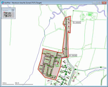
- Zoom in closer, so that you can clearly see the housing estate to the west of K350260.
- Values of all the objects of the same type included in a polygon can be edited at once. Change the Area Code to 41 for all nodes in the polygon:
- Select the nodes and links using Selection | Select objects in selected polygons.
- Choose Selection
 Selection operations Adjust selected values. In the Network Objects area of the Adjust Selected Network Values dialog, select
Nodes. In the
Field drop-down list, select 'Area Code (area)'. In the
Adjustment Value box, type '41', then click
OK.
Selection operations Adjust selected values. In the Network Objects area of the Adjust Selected Network Values dialog, select
Nodes. In the
Field drop-down list, select 'Area Code (area)'. In the
Adjustment Value box, type '41', then click
OK.
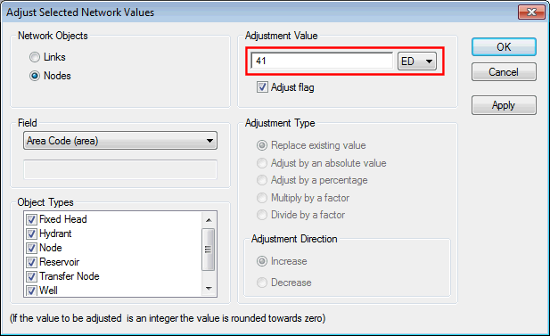
- Confirm the changes. You can use this method for changing the values for any selection, not just those contained in a polygon.
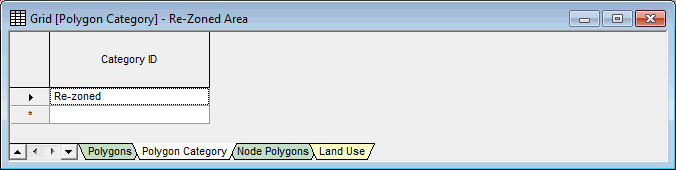
- We are now going to display a grid of all polygons and set up polygon categories:
- Select
Window Grid windows New polygons window. The grid view is displayed.
Alternatively, click the corresponding toolbar button.
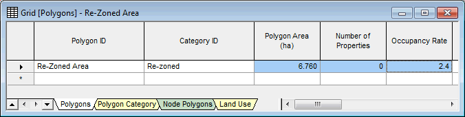
- The Category ID is shown as 'Re-zoned'. Click the Polygon Category tab to see the categories. Any category can be applied to other polygons.
Categories provide a means of grouping together. Each polygon can be included in only one category.
- Right-click the GeoPlan and select
Properties & Themes. The settings for the Polygons layer determine the way in which polygons are displayed. For example, clearing the
Display box results in all polygons being hidden.
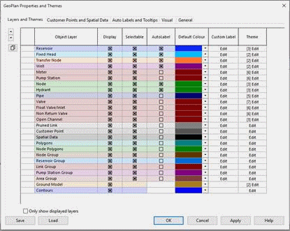
- Close the GeoPlan Properties And Themes dialog.
- Select
Window
- We are now going to illustrate how to copy the objects in the polygon to a new network:
- Create a network called 'Re-zoned Area' in the Newtown model group. Right-click Newtown in the Model Group window and select New | Network. Type the name in the New Name - Network dialog, then click OK.
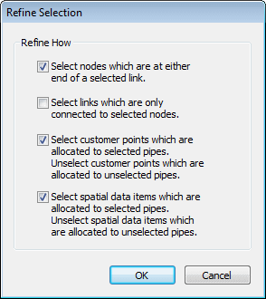
- In the network branched in step 1), use Selection | Refine selection to check that the selected objects form a viable group. The defaults are suitable, so click OK. This option ensures that there are no links that do not have a node at each end, that any associated customer points are included (along with any other spatial data items) and that any customer points (and other items) are excluded if they have been incorrectly included in the selection (because they are associated with links that are outside the selection).
- Copy the nodes and links with Edit | Copy object(s).
- Open the 'Re-zoned Area' network and select
Edit | Paste append object(s).
- Commit the Re-zoned Area network (without validation).
- Now that the polygon has been copied onto the new network, we can delete the re-zoned objects:
- In the original network (network branched in step 1), select
Selection Selection operations Delete all selected objects and confirm the deletion.
- Accept the defaults that are offered.
- Click No when asked if you want to leave allocated demands at nodes.
- If the selection did not include the connecting pipe (which now has no end node), delete it.
- The zoned area has now been removed.
- In the original network (network branched in step 1), select
Selection
- Commit the network (no need to validate) and close the GeoPlan window.
It is possible to compare the edited model with the network it originates from.
 Back to flowchart

Managing version controlled objects
Using the GeoPlan window