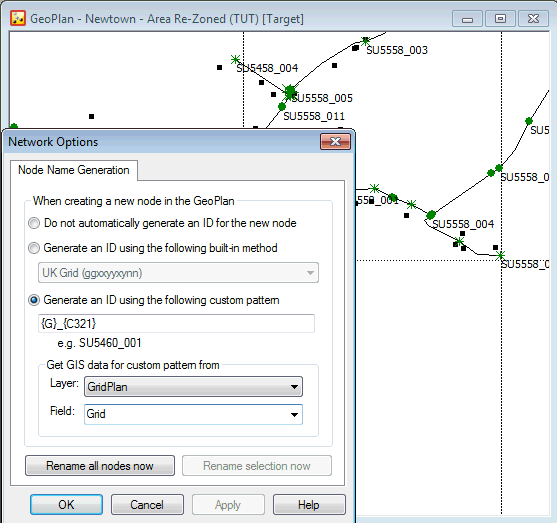
This page is used to:
- set up automatic name generation options when creating nodes in the network
- rename all or selected nodes based on a chosen naming scheme.
The page is displayed by selecting Network  Network options, then, if necessary, clicking the Node Name Generation tab.
| Item | Description | ||||||
|---|---|---|---|---|---|---|---|
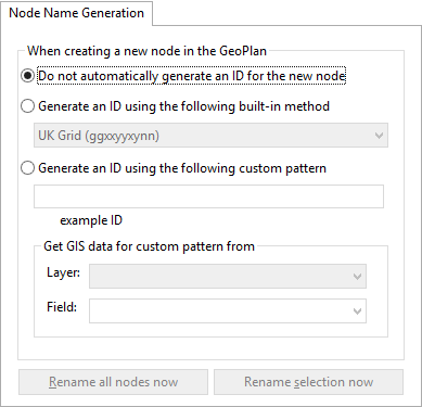
| Do not automatically generate an ID for the new node | If selected, disables automatic naming. | ||||||
| Generate an ID using the following built-in method |
For automatically naming nodes based on coordinates. If selected, the following options become available in the accompanying drop-down list:
See Built-in methods, below, for an explanation of these options. |
||||||
| Generate an ID using the following custom pattern |
For automatically naming nodes based on a custom pattern.
|
||||||
| Rename all nodes now (button) |
For renaming all the nodes in the GeoPlan, using the naming scheme selected above. Available only if a naming scheme has been selected above. Opens the Rename All Nodes dialog. |
||||||
| Rename selection now (button) |
For renaming nodes currently selected on the GeoPlan, using the naming scheme selected above. Available only if a naming scheme has been selected above and there is at least one node selected on the GeoPlan. Opens the Rename Selection dialog. |
Built-in methods
| Method | Description |
|---|---|
|
UK Grid |
Name based on the UK National Grid location. The name takes the form ggxxyyxynn where: gg are the letters identifying the 100 km grid square xxyy defines the point to the nearest kilometre xy further refines the location to the nearest 100 metres nn is a number added to the reference to make it unique (starts at 01 and is incremented until a unique ID is created) |
|
Irish Grid |
Name based on the Irish National Grid. The name takes the form Sgxxyyxynn where: S represents Ireland g is the letter identifying the 100 km grid square and the other parameters are as for the UK Grid option. |
|
XY8 |
This is an eight figure generic name generator for use with any map projection system. The name takes the form xxxxyyyy representing the x and y coordinates from the GeoPlan. In this case, InfoWorks WS Pro does not add a suffix to ensure the node name is unique. If the generated node name already exists, InfoWorks WS Pro will display a warning. It is up to you whether you add the node in a slightly different location, or add a suffix of your own to ensure a unique name. If the coordinates are too long for this format, a warning will be displayed with a recommendation to review the choice of built-in method. |
|
XY10 |
Ten figure version of the generic name generator described above. |
|
XY12 |
Twelve figure version of the generic name generator described above. |
|
XY14 |
Fourteen figure version of the generic name generator described above. |
Variables for custom patterns
| Variable | Description |
|---|---|
|
{X} |
A number based on the X coordinate of the node will be appended to the node name. The default is to append the X coordinate to seven digits (counting from the right). To adjust which X coordinate digits appear in the node ID, add the coordinate digit location to the variable. Example 1: {X4321} = four digits of X coordinate from right to left An X coordinate of 654132 will appear in the node ID as "4132" Example 2: {X4} = the fourth digit of X coordinate counting from right to left An X coordinate of 654132 will appear in the node ID as "4" |
|
{Y} |
A number based on the Y coordinate of the node will be appended to the node name. The default is to append the Y coordinate to seven digits (counting form the right). To adjust which Y coordinate digits appear in the node ID, add the coordinate digit location to the variable. Example 1: {Y4321} = four digits of Y coordinate from right to left A Y coordinate of 261839 will appear in the node ID as "1839" Example 2: {Y4} = the fourth digit of Y coordinate counting from right to left A Y coordinate of 261839 will appear in the node ID as "1" |
|
{C} |
A count will be appended to the node name. The count will be incremented for each node that would otherwise have the same ID. The default is to append a count of two digits, e.g. Node_{C} = Node_01, Node_02, etc. To adjust the number of digits, add the number of significant places required to the variable. e.g. Node_{C4321} = Node_0001, Node_0002, etc. To adjust the starting point of the count, add "+" followed by the number from which counting is to start. e.g. Node_{C21+50} = Node_50, Node_51, etc. Note: The {C} and {?} variables can not be used in the same pattern.
|
|
{G} |
GIS data from a nominated layer in the GeoPlan will be appended to the node name. When using the {G} variable, the Get GIS data for custom pattern from section will become available. This section contains dropdown lists of layers displayed in the GeoPlan and the fields of the selected Layer. This is of particular use when using a coordinate grid layer. Example
To adjust which characters of the GIS Layer Field appear in the node ID, add to the variable the digits corresponding to the location of characters in the field. The characters are numbered from left to right. e.g. from layer field containing grid coordinates in the form SU5163 {G3456} = 5163 |
|
{?} |
This character is used to prompt for user input when creating node IDs. When creating nodes, the node name dialog will be displayed with a "?" character in the node name. The "?" character will be highlighted, ready for the user to over-type. Multiple "?"s may be included within the curly brackets to give an indication of the number of characters to be entered by the user. However, only one instance of this variable item may be used. Renaming of existing nodes cannot be carried out when using the {?} variable. Note: The {?} and {C} variables can not be used in the same pattern.
|