This page provides the features and improvements in the previous versions of the application.
For the What's New in the latest release, refer to What's New.
What's New in Version 2025.5
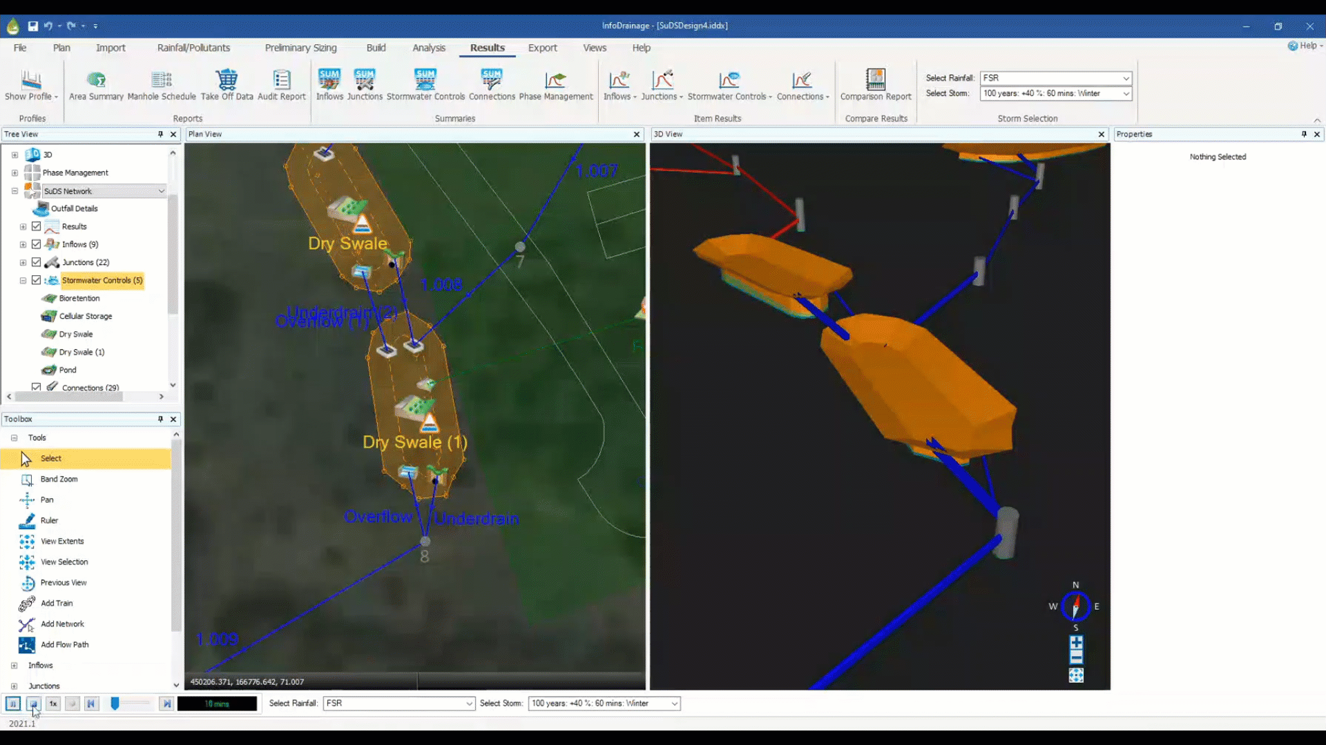
Simulation Health Reporting
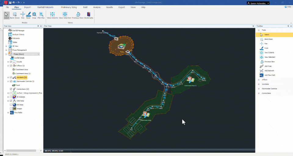
We are introducing Simulation Health Reporting in InfoDrainage 2025.5, a new capability designed to enhance the identification and troubleshooting of continuity and convergence errors within hydraulic models. This feature provides a detailed breakdown of simulation errors flagged by the SWMM engine and links them to specific components within the model for efficient resolution.
With this update, Simulation Health Reporting delivers:
Error Breakdown by Model Components: Simulation issues, such as continuity errors, are categorized and presented by specific model elements, enabling targeted troubleshooting.
Error Context Integration: Each error is accompanied by critical contextual information, including:
- Error type
- Storm scenario where the error occurs
- Direct link (Go To button) to the exact problematic location in the plan view
This update ensures that you can confidently resolve errors and optimize your drainage designs, resulting in greater model performance and reliability.
What's New in Version 2025.4
Land Use and Soil Type Polygons (Tech Preview)
In this Tech Preview, we are introducing enhanced sub-catchment modelling capabilities through the addition of Land Use and Soil Type polygons. This feature allows you to incorporate detailed polygon attributes to refine hydrological calculations for each sub-catchment, providing a more accurate and spatially informed approach to drainage design.
With this update, land use polygons come with specific attributes that reflect different surface and environmental conditions. Each land use polygon can include:
- Land Use (e.g., Urban Areas)
- Cover Type (e.g., Open Space)
- Condition (e.g., Poor)
- Volumetric Runoff Coefficient (e.g., C = 0.84)
- Percentage of Impervious Area (e.g., 80%)
Soil type polygons, in turn, incorporate Soil Group values as an attribute (e.g., Soil Type A).
These polygons provide essential data points that dynamically inform key hydrological parameters, such as the SCS curve number, percentage impervious, volumetric runoff coefficient, and Laurenson method degree of urbanization. By enabling composite and weighted average calculations, this functionality supports a more detailed representation of mixed land use and varied soil properties across sub-catchments.
What's New in Version 2025.3
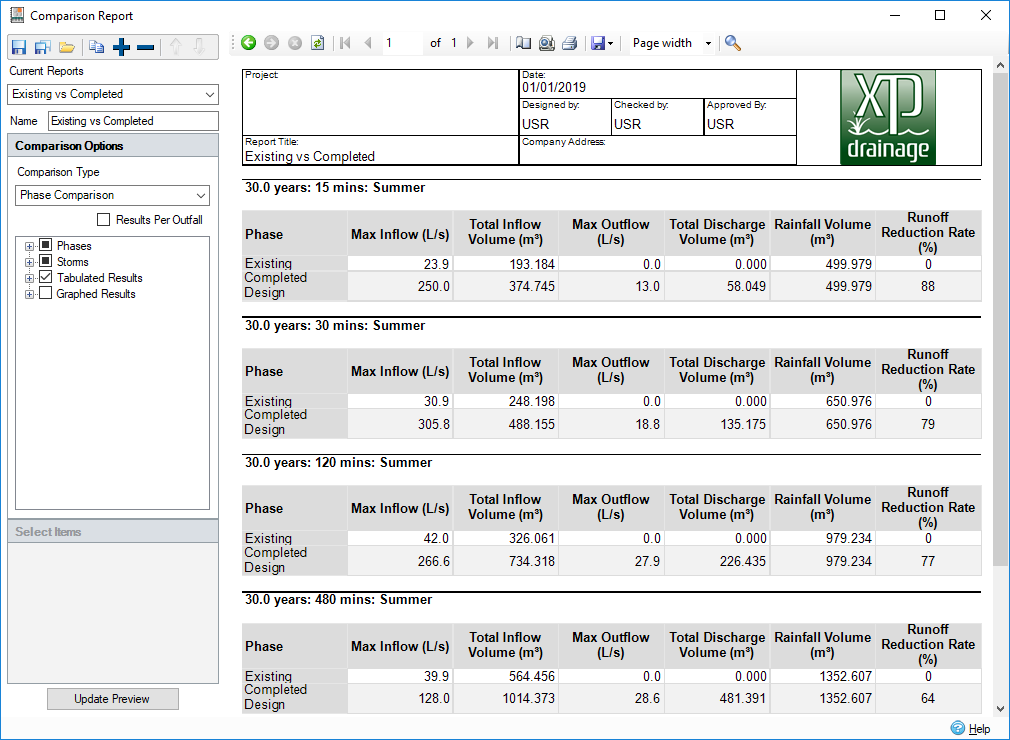
Flexible Reporting - Part 3
We are pleased to announce the release of Flexible Reporting Part 3, which marks the transition from the tech preview phase to full availability. This update introduces enhanced capabilities for summarizing inflow data within reports, providing a more streamlined and informative output.
Summarized Inflow Data: For multiple contributing subcatchments, inflow data is now summarized in a single column for clarity and ease of analysis. For example:
- Subcatchment Areas: The areas of all contributing subcatchments are automatically summed, providing a total area value.
- Runoff Coefficient and Impervious Percentage: These metrics are presented as weighted averages, giving a more accurate representation of the overall runoff characteristics.
- Runoff Methods: The various runoff methods used across subcatchments are listed, allowing for a comprehensive view of the contributing inflow processes.
This enhancement aims to improve the way inflow data is presented, making it easier for you to interpret and utilize in you drainage design workflows.
Outfall Behavior Control
In response to user feedback, we have introduced a new feature that allows you to better control outfall behavior in the presence of surcharged outfalls or tailwater conditions. Traditionally, InfoDrainage has operated under the assumption that outfalls are gated, meaning that tailwater conditions do not propagate upstream to utilize the network volume beneath the tailwater elevation. While this assumption holds true for most scenarios, there are cases where outfalls are not gated, allowing water to propagate upstream and utilize the available volume under the tailwater elevation.
Gated vs. Non-Gated Outfall Simulation: A new checkbox has been added to the software, enabling you to choose between gated and non-gated outfall behaviours:
- Gated Outfall: Selecting this option maintains the traditional assumption, where the tailwater does not influence the upstream network.
- Non-Gated Outfall: When this option is selected, InfoDrainage will simulate scenarios where tailwater can propagate upstream, allowing water to utilize the volume beneath the tailwater elevation.
This enhancement provides greater flexibility and accuracy in modelling the physical reality of the site conditions, ensuring that your simulations can accurately reflect the specific characteristics of your drainage system, whether outfalls are gated or not.
What's New in Version 2025.2
Flexible Reporting – Part 2 (Tech Preview)
Following the release of Flexible Reporting Tech Preview Part 1, we’re excited to announce the release of Tech Preview Part 2 for the Flexible Reporting tool in InfoDrainage. This update brings a suite of enhancements based on user feedback, including a critical storm button to easily access key hydraulic modelling results and the ability to move columns, ensuring attributes are in the preferred order. Users can now also sort columns numerically and alphabetically, save and load templated reports, and add attributes related to inlets and outlets such as orifices diameters and weirs crest levels. These improvements aim to provide even greater flexibility and efficiency in generating comprehensive and tailored reports. We look forward to your feedback on these new features. Please keep sending us your feedback to:
FeatureFeedback.InfoDrainage@autodesk.com
Culvert Analysis
We are excited to introduce SWMM-based analysis capabilities for culverts in InfoDrainage. Users now have access to a comprehensive selection of 57 culvert types, including circular, box culverts, ellipses, and arches, with various shapes and entrances. This new feature enables more accurate and detailed modelling of culvert behaviour, enhancing the overall drainage design process.
Speed Improvements
We are pleased to announce a significant performance enhancement in InfoDrainage. By switching off the background 3D rendering updates of drainage networks, we have improved the software’s speed and reduced RAM consumption by up to a third. While the 3D view remains available, it will no longer update continuously with each change, allowing for a more efficient and smoother user experience. It’s important to note that 3D views remain available inside of InfoDrainage. We’ve simply updated the software to no longer continuously update with each change, making your experience smoother and more efficient. Essentially, it ensures that you can work on what you need to, how you need to, without compromising on the functionality of the 3D view.
What's New in Version 2025.1
Flexible Reporting (Tech Preview)
The latest release brings a Tech Preview of the Flexible Reporting to all InfoDrainage users, enabling you to expose all of the available inputs, outputs, simulation results, and design results for all elements in the model (Connections, Structures, Inflows and Stormwater Controls) in one table based on their connectivity.
You can filter by Phase, Flow Path, and storm event, enabling more flexibility in generating reports that target a particular area of the site.
It is important to note that you must run the rational calculations (or the design wizard) and simulate your network to expose all the results; otherwise, you will not be able to access these attributes.
Over the last year, we have heard this feature requested from users more than any other feature, so we are excited to be rolling it out to get customers’ feedback on the new feature before it is officially released. This will enable users to explore and test the functionalities of the Flexible Reporting. Please send your feedback to:
FeatureFeedback.InfoDrainage@autodesk.com
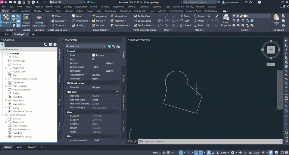
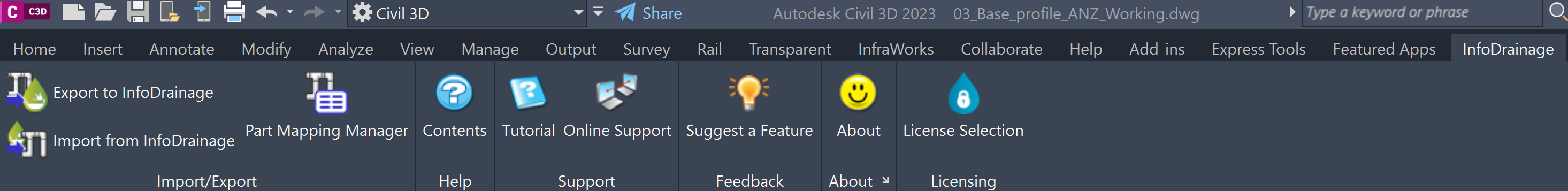
Enhanced Integration with Civil 3D
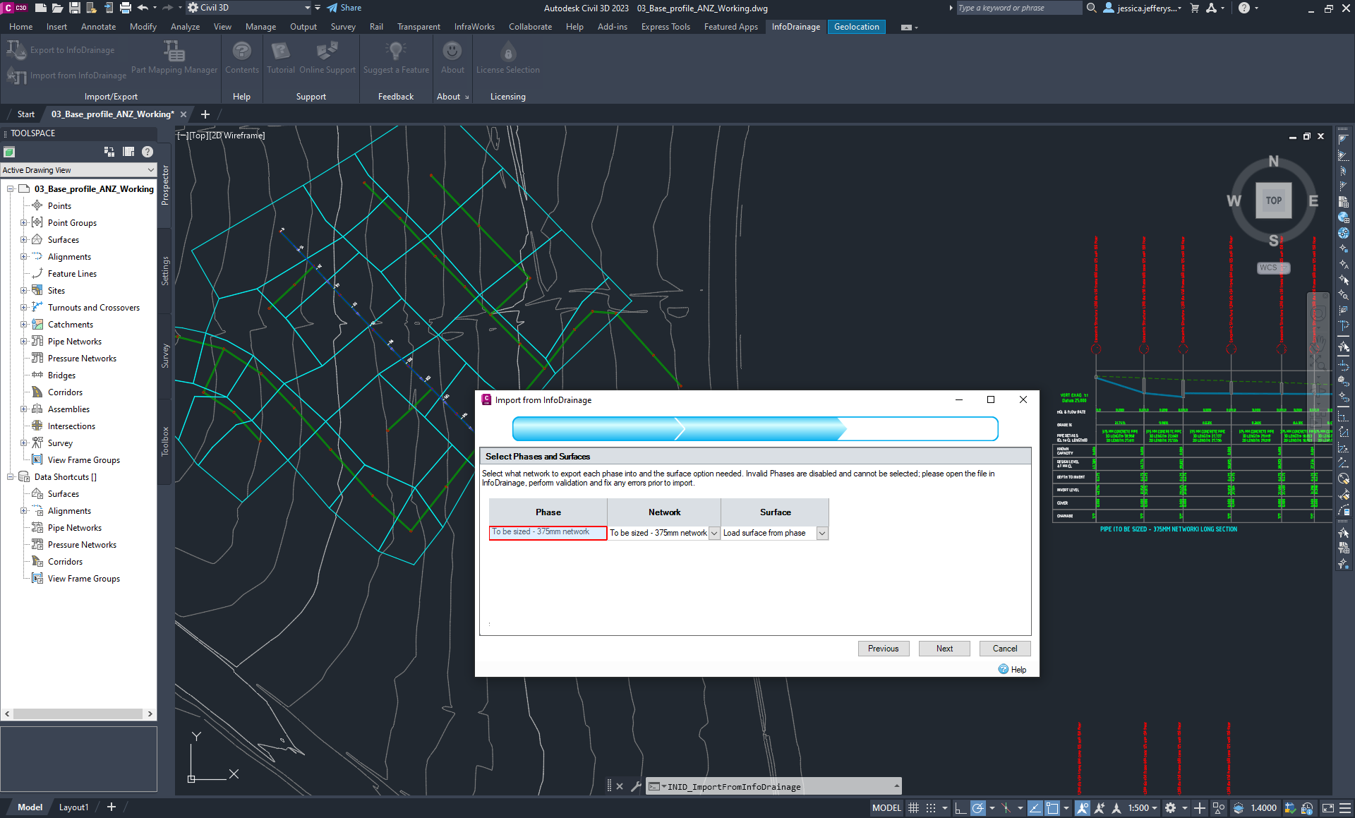
We are excited to announce a significant enhancement to the integration between InfoDrainage and Civil 3D, aimed at further streamlining your drainage design workflows. This new feature enables the seamless transfer of hydraulic modelling results from InfoDrainage to Civil 3D, extending the capabilities of your design and analysis capabilities, enabling informed design decisions and more flexible and streamlined reporting.
Key Features of the Enhanced Integration:
Maximum Flow Values: This enables users to run simulations in InfoDrainage and transfer the maximum flow values directly to the corresponding pipe properties in Civil 3D. This ensures that all flow-related data is accurately represented in your Civil 3D models.
Return Period Values: The integration also supports the transfer of Return Period values to the pipe properties within Civil 3D. This helps you establish the storm frequency associated with the hydraulic modelling results in the Civil 3D model.
Maximum Velocity Values: You can now send maximum velocity values from InfoDrainage to the extended dataset within Civil 3D. This helps inform a more detailed analysis of flow velocities within the drainage network, helping to identify potential areas of concern and optimize the network parts/materials to provide protection where needed.
By incorporating these additional hydraulic modelling results, you can achieve a higher level of detail and accuracy in their Civil 3D projects. The enhanced integration facilitates a smoother round-tripping process, allowing for more efficient design iterations and improved project outcomes.
New attributes/results introduced to the simulation summaries
We are pleased to introduce a set of new attributes in the simulation results for both pipes and manholes within InfoDrainage. These additions are designed to provide you with a more comprehensive overview of your drainage system's performance in a tabular format, facilitating more informed decision-making and enhanced drainage design reporting.
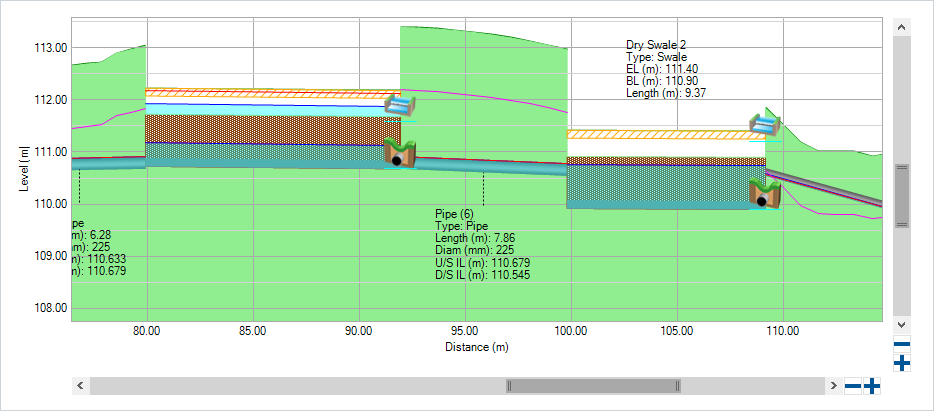
HGL and EGL in Simulation Summary Table
Hydraulic Grade Line (HGL) and Energy Grade Line (EGL), previously displayed only in the pipe long-section, are now included in the simulation summary table. This enhancement allows for quick and easy access to HGL and EGL results improving the efficiency of your analysis and reporting processes.
Freeboard Reporting
The Freeboard attribute, representing the distance between the maximum water level and the ground level, is now reported in the simulation summary. This provides crucial information on the safety margins within your drainage system, helping to identify areas at risk of flooding.
Benefit: With freeboard data included in the summary, you can easily evaluate and ensure adequate safety margins throughout your design, enhancing the resilience of your drainage infrastructure against potential overflow events.
Detailed HGL and EGL Reporting for Pipes
For pipes, we now report HGL and EGL values at both the upstream and downstream ends (HGLup, EGLup, HGLdown, EGLdown). This detailed reporting offers a more granular view of the hydraulic conditions along the pipe length, facilitating better analysis and troubleshooting and more efficient round-tripping with Civil 3D as these new attributes match the Civil 3D pipe properties.
These enhancements are designed to provide you with a richer set of data, enabling a more thorough understanding of your drainage system's performance. The inclusion of these new attributes in the simulation results summary ensures that you have all the necessary information at your fingertips to make informed design decisions, ultimately leading to more robust and efficient drainage solutions.
What's New in Version 2025.0
Pond and Swale stamping integrated with the Machine Learning Deluge service
We are excited to introduce groundbreaking enhancements to our deluge analysis capabilities. One of the key advancements in InfoDrainage 2025.0 is the integration of user-defined ponds and swales into our machine learning-based flood mapping technology. In previous versions, our machine learning algorithms provided valuable insights into deluge flood patterns but were blind to the presence of user-introduced features such as ponds and swales.
With the introduction of this new enhancement in 2025.0, you now have the ability to stamp your ponds and swales directly onto the surface within the InfoDrainage environment. By incorporating these user-defined features into the analysis, our ML deluge algorithm can generate updated flood maps that accurately reflect the impact of ponds and swales on the deluge flood maps.
By accounting for user-defined features, engineers and designers can make more informed decisions from the outset when planning drainage systems and mitigating flood risks.
What's New in Version 2024.4
Intelligent Deluge Flood Mapping with Machine Learning Technology
We are excited to introduce a first step into a transformative feature that accelerates the flood risk assessment process: a machine learning-based tool for deluge flood mapping. This tool is designed to streamline your workflow by generating detailed flood maps without the need for time-consuming hydraulic simulations.
Traditional flood mapping often involves complex simulations that can be computationally intensive and time-consuming. Our new machine learning tool addresses this issue by utilizing advanced algorithms that quickly analyze water depth across a site. The result is a rapid and accurate flood map that provides essential data in a fraction of the time typically required.
In a groundbreaking move, this machine learning tool will serve as a direct replacement for traditional deluge methods. This marks a foundational step towards enabling interactive functionalities, where you will be able to move ponds and swales within the flood map and receive real-time feedback on the hydrological impacts.
The machine learning-based flood mapping tool is designed to be user-friendly, requiring minimal setup. Just input your site ground data, run the Interactive Machine Learning Deluge and the algorithm will produce a comprehensive flood map without solving one equation.
Results migration from InfoDrainage to Civil 3D
In our ongoing effort to optimize the workflow between InfoDrainage and Civil 3D, we are thrilled to announce an instrumental feature in InfoDrainage 2024.4 - direct migration of hydraulic modelling results along with the drainage model. This enhancement significantly broadens the capabilities of InfoDrainage by allowing for a more intricate level of data interoperability between the two platforms.
Previously, while you had the ability to export the physical drainage model to Civil 3D, the hydraulic modelling results remained in isolation within InfoDrainage. This necessitated a manual process for engineers who wished to visualize and integrate hydraulic data in Civil 3D.
The new feature eradicates this inefficiency, providing a unified modelling experience. You can now directly transfer not only the drainage system model but also the relevant hydraulic data, including hydraulic grade line and energy grade line results to Civil 3D.
By capitalizing on this direct data migration, you can enrich your Civil 3D projects with more context and analysis. You can easily plot long sections that incorporate the hydraulic grade line and energy grade line, thereby achieving a more comprehensive understanding of the drainage system's behavior. This offers an invaluable advantage in accurately assessing, designing, and modifying drainage infrastructure.
You would need to download AutoCAD version 2024.1 and Civil 3D version 2024.1 in order for the result migration to work.
Speed and scalability improvements
In our continuous dedication to delivering a stable and high-performing software experience, we have conducted extensive investigations to identify and fix memory leaks within InfoDrainage and this time, the investigation was focused on the Civil 3D integration. These improvements are part of our ongoing endeavor to enhance the reliability, efficiency, and user experience of our software.
Our engineering team undertook a meticulous review of the software's architecture, employing advanced diagnostic tools to locate memory leak issues that could impact performance over extended periods of usage. This deep-dive allowed us to pinpoint specific areas requiring optimization, which have been addressed in this latest release.
Memory leaks, even if minor, can cumulatively result in reduced software performance and unexpected crashes, especially in prolonged sessions. By rectifying these leaks, we have substantially improved the software's speed, scalability, stability and efficiency, ensuring that you can operate InfoDrainage for longer durations without performance degradation.
These enhancements are integrated into the latest version of InfoDrainage, requiring no additional steps on your part. Simply update to the latest version to benefit from the enhanced stability and performance features.
What's New in Version 2024.3
Cloud Analysis Capability
InfoDrainage has achieved a significant milestone in its journey towards enhanced operational excellence: the migration of our rainfall and runoff services to the cloud. This development, while not currently yielding speed improvements in hydraulic simulations, introduces a number of compelling advantages. Most importantly, this transition enhances operational resilience through a robust, multi-regional data center architecture, thereby mitigating the risks associated with hardware failure and local power outages. Additionally, the cloud-based platform offers unprecedented scalability, seamlessly accommodating both small-scale and large-scale projects. It also facilitates future efficient remote collaboration, allowing for geographically dispersed drainage designers and site designers to work together in real time. Moreover, the move serves as a long-term, cost-effective alternative by eliminating the need for costly on-premise hardware and maintenance.
Clash Detection Analysis for Stormwater Controls (SWCs)
Following the successful integration of clash detection (within InfoDrainage Ultimate) between pipes and manholes in our previous release, we have extended these functionalities to include Stormwater Controls, which significantly enhances the utility and comprehensiveness of our clash detection capabilities. This latest addition helps creating a comprehensive, all-in-one solution for drainage design and hydraulic modelling.
In complex projects, the need for a tool that can quickly identify design conflicts is paramount. Recognizing this, we have expanded our clash detection capabilities to cover:
Pipes and Stormwater Controls: Whether it's a storage structure, swale, or rain garden, InfoDrainage can now identify any spatial conflicts between these stormwater control measures and your pipeline layout.
Manholes and Stormwater Controls: With this update, you can ensure that manholes are optimally placed with respect to stormwater controls, thus avoiding redesigns and project delays.
Stormwater Controls with Stormwater Controls: InfoDrainage can detect clashes between different types of stormwater controls. This allows for a more coherent and efficient layout, which is crucial for effective water management and environmental protection.
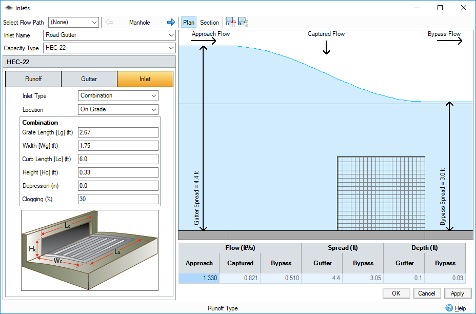
HEC-22 Advanced Inlet Analysis Capabilities
InfoDrainage now allows for the analysis of networks with multiple types of inlets, expanding beyond our prior capabilities. This flexibility enables you to model and analyze more complex and customized drainage systems accurately. As an extension to our existing HEC-22 inlet capabilities, this release allows for a nuanced examination of each HEC-22 inlet type. Whether you are working with curb openings, grates, or combination inlets, InfoDrainage now supports a more detailed analysis, offering further insights into system performance and effectiveness.
What's New in Version 2024.2
Clash Detection Analysis
In line with our continued dedication to offering advanced, user-friendly solutions in drainage system design, we are thrilled to unveil the new Clash Detection tool, an addition to the InfoDrainage suite.
Clash Detection Tool: This tool has been developed to be an essential asset for intricate drainage system design. It is specifically engineered to identify and visualize 'clashes' or intersections between different components within your design, such as pipes, channels, or other structures.
One of the key features of the Clash Detection tool is its ability to identify both horizontal and vertical separations. Users have the flexibility to set specific values for both horizontal and vertical separation. Should these values fall below the thresholds set by the user, the software will automatically flag and visually highlight the clash by drawing a circle at the conflict point.
This proactive approach to design helps prevent potential issues that could arise during construction or operation, ensuring a more efficient and reliable system. By providing early detection of such conflicts, the tool allows for immediate corrective actions, thus minimizing potential construction delays and optimizing system performance.
Furthermore, the Clash Detection tool is seamlessly integrated into our reporting structure. Clash detection results can be included in the audit report, providing a thorough and detailed assessment of your design. Moreover, for those preferring a more spatial analysis, the locations of detected clashes can be exported to CAD. This added flexibility ensures you have complete control over your design and review process, in the format that suits you best.
HEC22 Inlets Improvements
We have significantly enhanced our HEC-22 inlet calculations, bringing them a step closer to accurately reflecting real-world conditions. Previously, our software offered a simplified version of these calculations. However, we recognized the importance of more nuanced variables in these calculations for our users.
Therefore, we have extended the HEC22 inlet calculations provided by SWMM5 in order to increase their usability in the context of design and sizing. Our improved HEC-22 inlet calculations now account for the grate type and the throat angle, both critical factors affecting water inflow rates into the inlet. By incorporating these parameters, we aim to provide a more realistic representation of how drainage inlets perform under varying conditions.
These enhancements mean that you can now make more precise predictions about your drainage system's performance, giving you greater confidence in your designs and ultimately leading to more efficient and effective drainage systems. This upgrade underscores our commitment to continually refining InfoDrainage, integrating best-in-class capabilities to ensure you have the tools you need to produce outstanding drainage system designs.
What's New in Version 2024.1
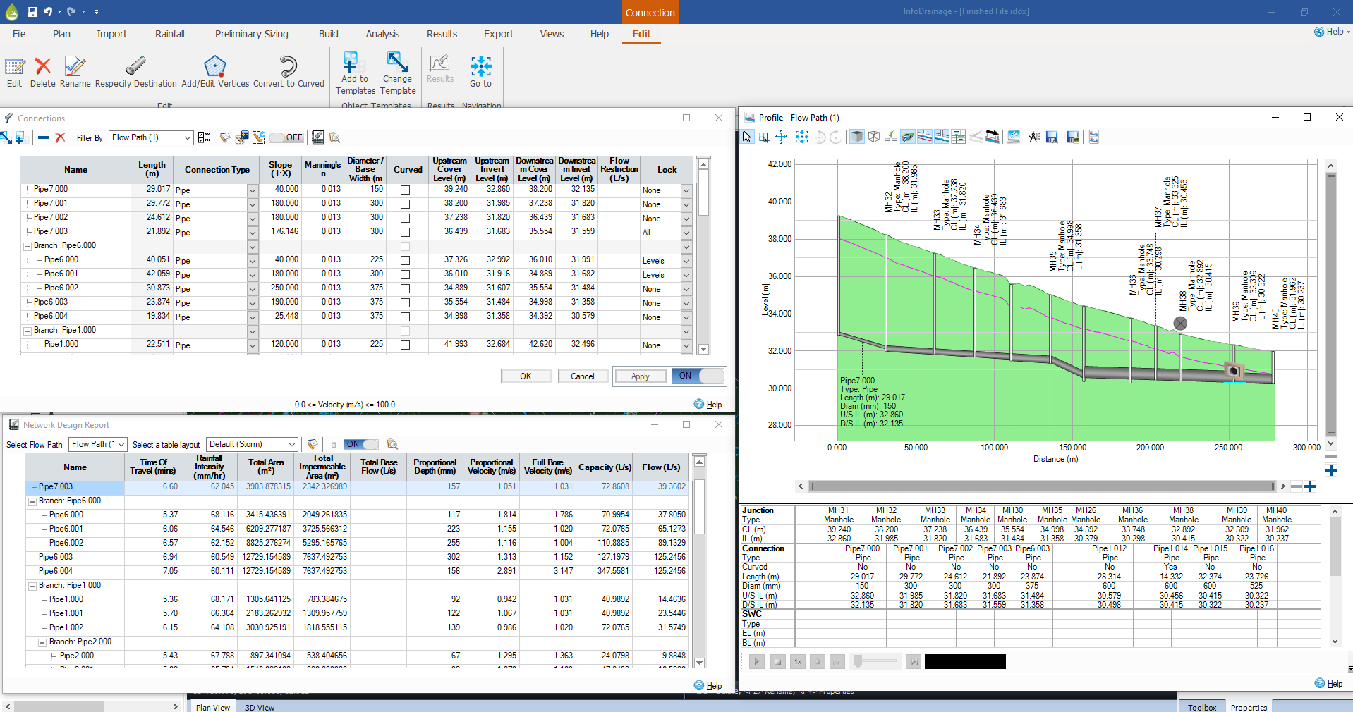
Hydraulic Grade Line and Energy Grade Line
In our constant mission to provide you with a robust and intuitive drainage design software, we have enabled you to plot the Hydraulic Grade Line (HGL) and Energy Grade Line (EGL) within the long section of the drainage network.
Hydraulic Grade Line (HGL) - This is a graphical representation of the pressure and gravitational potential energy of water flowing through your drainage system. Essentially, the HGL shows the energy level of the water as it flows through pipes, channels, or other conduits and allows you to visualize the change in energy due to pipe friction and changes in elevation.
Energy Grade Line (EGL) - This depicts the total energy available to the water, which includes the energy related to water velocity in addition to what is reflected in the HGL.
Plotting both the HGL and EGL gives you a clear, comprehensive view of how energy is distributed and changes throughout your drainage system. This helps you identify potential problem areas, such as bottlenecks, sections of the system where water may not drain effectively, or areas where high velocities could cause erosion or damage to the system.
This new feature represents our commitment to offering powerful, accessible tools for sophisticated drainage system design.
Part-family Awareness in InfoDrainage
As a significant new addition to our drainage design software, we have enabled you to specify the materials for pipes and structures/manholes directly within your project. Pipes and manholes are fundamental components of any drainage system and the materials used for these elements can significantly influence the construction cost as well as the durability under various constraints (for example, shallow pipes).
Pipes Part-Family - With this new feature, you can now specify and select the type of material used for the pipes in your drainage designs. Being aware of the pipe materials during the design process allows you to make and communicate informed decisions considering project requirements and constraints.
Manhole Material Part-Family - Similar to pipes, the material used to construct manholes can greatly affect their lifespan, cost and overall system efficiency. Our new feature lets you specify the manhole/structure type or material so this becomes an output of the drainage design rather than an afterthought.
If you realize that you have two names used for the same part-family, you can simply use the merge function, which will not only merge the part-family list but will also update the drainage network accordingly.
This new feature also facilitates improved communication and coordination with stakeholders, contractors, and material suppliers, as drainage designs will now include explicit material specifications. This ensures that the correct materials are used during construction, minimizing potential issues and discrepancies.
Improved mapping when roundtripping with Civil 3D
With the part-family awareness in InfoDrainage being introduced, we have enabled you to preserve the pipe/structure part-family when round tripping with Civil 3D. Previously, the drainage network would be categorized in the mapping process based on size, now with the improvements introduced, the mapping logic would categorize the pipes and structures based on size and material. For example, if the mapping logic detects two pipes of similar size (for example, 300mm) and different materials (for example, concrete and HDPE), these two pipes will be presented in the mapping in two different rows so you can assign a different part-family to each of them.
Automated mapping when roundtripping with Civil 3D
With the part-family awareness in InfoDrainage being introduced, we have enabled an automated mapping whilst round tripping between InfoDrainage and Civil 3D. If you use the same part name in InfoDrainage, the software will detect the name and the size of the pipe/structure and link it directly to a part-family and a part-size from the existing list.
What's New in Version 2024.0
Design Logic Switch
The design logic switch is a tool that improves the flexibility and efficiency of the drainage design process. This innovative tool solves the problem of trade-offs between conflicting design objectives by providing a user-friendly interface for you to make informed decisions. The combo box allows you to easily select between two different design logics, one that minimizes excavations and slope, and the other that minimizes pipe diameters.
FEH 2022 support
InfoDrainage now supports the new FEH 2022 design rainfall. This latest release enables the use of the updated design rainfall methodology for the UK. InfoDrainage now enables you to use the most up-to-date and accurate design rainfall methodology, allowing you to design more effective and traditional and sustainable drainage systems. The updated runoff method is not yet supported as it has not been released yet, when trying to apply FEH22 on ReFH2 (2013 version) you will be given a warning that you should use FEH13 instead.
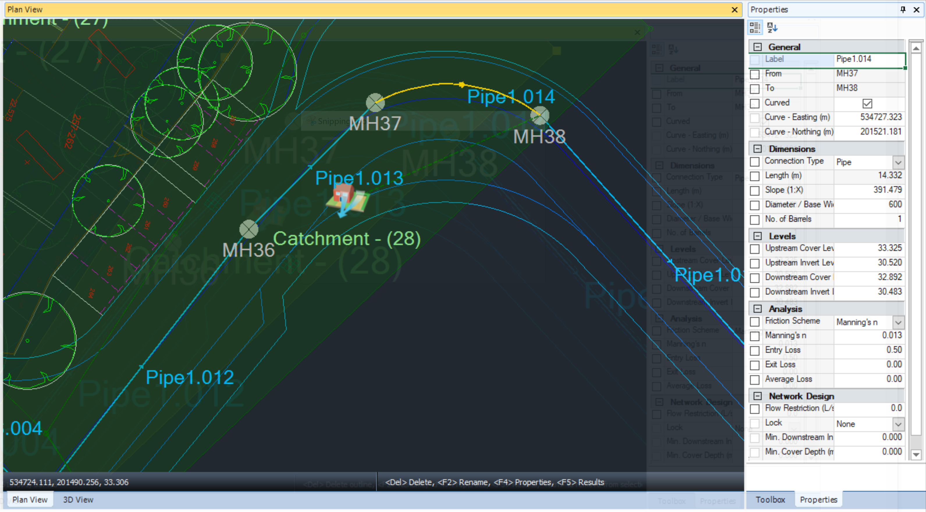
Arc pipes
We have introduced a new capability in InfoDrainage that will make it easier for you to export curved pipes to Civil3D. With this new feature, the software will no longer have to make assumptions that the curved pipe is a series of polylines. Instead, you can now export curved pipes natively from InfoDrainage to Civil3D. This capability will streamline the workflow for designers who need to work with curved pipes, and improve the accuracy and efficiency of their work.
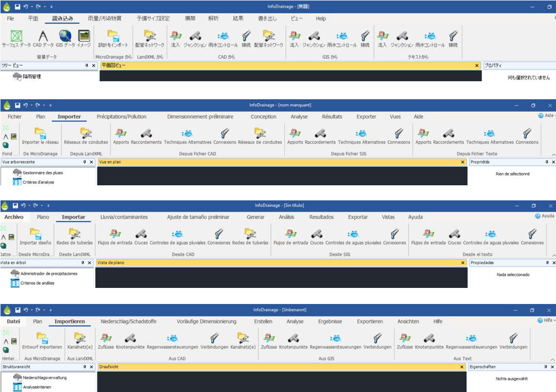
Localization
We have expanded the accessibility of our software by translating the graphical user interface into several languages, including Spanish, French, Japanese, German, as well as UK and US English. Now users around the world can seamlessly navigate and use our software in their native language. This enhancement further demonstrates our commitment to providing the best user experience and making our software accessible to everyone.
What's New in Version 2023.3
Extended datasets
To avoid the loss of data during roundtripping between InfoDrainage and Civil 3D. We ensured that data present in InfoDrainage could be accessed in Civil 3D via Property Sets so that it can be used in additional workflows, including costing, clash detection, additional infrastructure design, and construction.
This update enhances Civil 3D interoperability using the extended datasets within Civil 3D. You can now expose the hydraulic/hydrology parameters of the pipes, subcatchments, and stormwater controls within Civil 3D and can also manipulate some of the parameters within Civil 3D.
Improved Meshing Engine
The meshing engine/logic has been improved, especially when meshing around Stormwater Controls and channel banks.
Supporting Arcs in InfoDrainage
The support for CAD data has been improved, with arcs now considered when loading polygons for Inflows or Stormwater Controls.
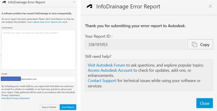
Crash Reporting Tool (CER)
InfoDrainage has integrated Autodesk customer error reporting (CER), which allows you to report exceptions that occur in the software for diagnostic purposes.
RealDWG
The support for importing and exporting DXF/DWG files has been replaced with the Autodesk platform, RealDWG, which enhances the support and makes it faster and more stable.
For information about the improvements in earlier versions of the application, refer to Improvements in Previous Releases.
What's New in Version 2023.2
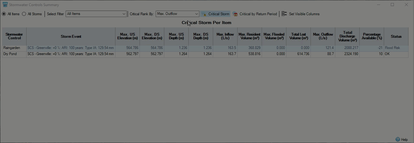
Results – Extended Critical By Options
Critical Duration Analysis now provides a broader spectrum of parameters to evaluate the critical duration of Stormwater Controls, Junctions and Connections.
Countrification – Australia
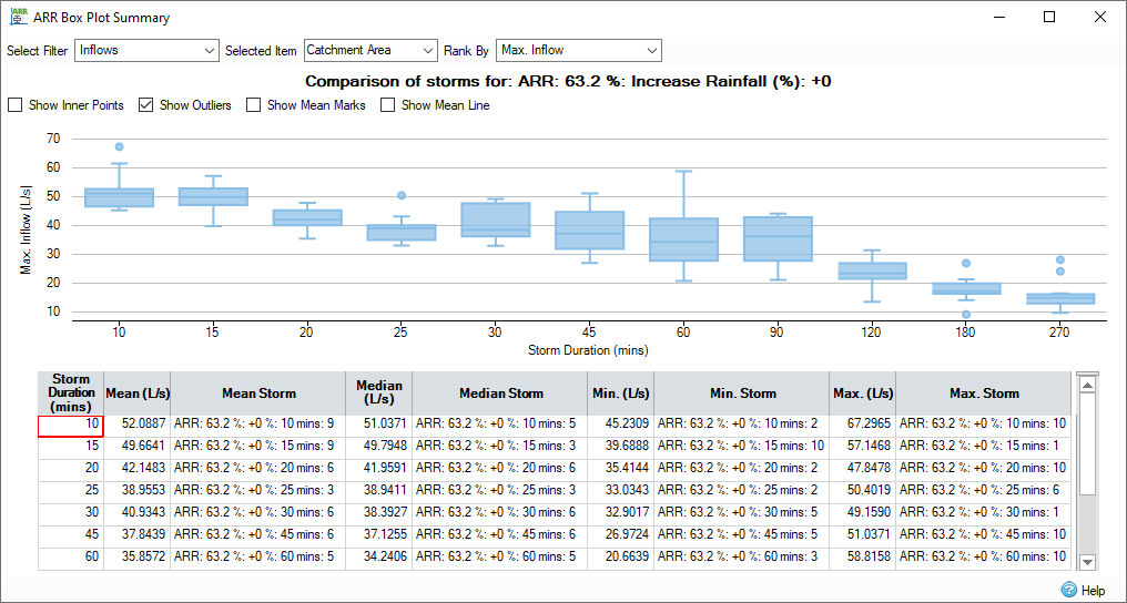
InfoDrainage now connects to the Australian BOM website to gather the ARR19 Rainfall data to generate the storm events for design workflows.
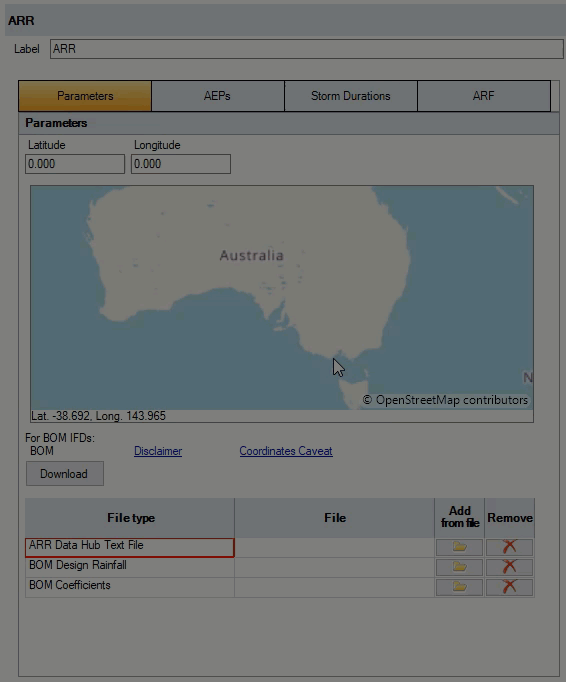
The ARR19 Box and Whisker Plot is also included.
Countrification – United States
InfoDrainage now connects to the US NOAA website to gather the latest Atlas 14 rainfall and temporal patterns required to generate design rainfall events. The NOAA rainfall also includes the latest NRCS temporal patterns generally required to be used with Atlas 14 rainfall events.
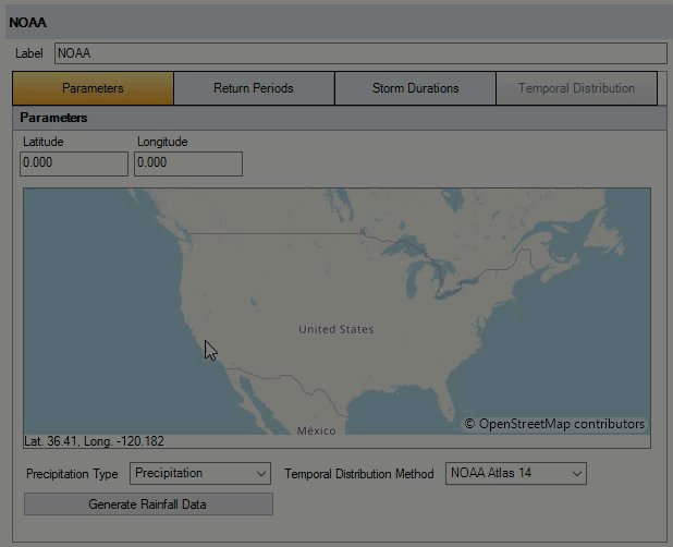
InfoDrainage now includes US-Survey feet as a unit.
Localization
InfoDrainage default language is now US English.
Civil 3D Roundtrip workflows
InfoDrainage and Civil 3D roundtrip workflows now support the reduced validation requirements for an import of an InfoDrainage design into Civil3D, better part mapping on Import and Export to speed up the process of multiple iterations, and increases the InfoDrainage data that Civil 3D can recall on export to a InfoDrainage model, thereby reducing site data rework.
InfoDrainage now includes US-Survey feet as a unit.
What's New in Version 2023.1
Improved Roundtripping with InfoDrainage for Civil 3D
Maintaining Objects
Styles, annotations, and linked objects are unaltered during the return to Civil 3D, thereby helping to maintain data integrity.
Network Selection on Import
Updated import options identify invalid networks and allow network selection, saving time and reducing manual steps updating networks.
Curved Connections
Curved connections can be drawn, imported, and exported via AutoCAD Civil 3D and MicroDrainage files lessening the need for approximations.
Improvements in Network Design
Sealed Manholes
Sealed manholes can be designated which do not flood, making it easier to communicate models with stakeholders. MicroDrainage support for Import and export is now possible. Markings for Sealed Manholes visible in Plan, Profile, and 3D View.
Toggles for Live Updates during Design
Set Toggles to ON to work with Connections form, Network Design Wizard, and Network Results in Live mode to adopt changes immediately, update the network, or allow multiple edits and Network Design Wizard to run manually. Giving the most flexibility and clarity in how a network will respond to changes.
Additional Locking Options
Lock pipes during Network Design with options for Connections and Junctions to lock 'All' dimensions or "Elevations " only. Elevation locking fixes slopes and invert elevations yet allows sizing to occur and allows designs to work around existing underground infrastructure.
Improved Elevation Syncing
Working with the lock options - elevations will automatically sync between connections and junctions unless lock options are set.
Sump Depths
InfoDrainage now supports Sump depths on manholes to allow elevation syncing to occur above the sump. Sump Depth values roundtrip to AutoCAD Civil 3D for improved accurateness in exchange.
Total Analysis Speed Improvements
Results processing now allows multi-threading providing significant speed improvements in overall analysis and workflow efficiencies.
SWMM Runoff
InfoDrainage now supports SWMM Runoff methods, including multiple Infiltration Methods.
What's New in Version 2022.1 & 2023.0
Import Pipes and Manholes from CAD Files
Allow the import of Connections and Junctions from CAD files to reduce manual steps tracing existing data from .dwg and .dxf files. Available separately or combined when Importing a Pipe Network saving time in model setup.
Network Design Improvements
Continued improvements in the Network Design workflow to provide flexibility for different ways of working and the ability to update models faster. Includes the following:
- Single click rerun Network Design Wizard
- 'Finish' button added to Network Design Wizard
- Option to 'Exclude Branch Lines' from sizing in Network Design Wizard
- Cover Depth column added to wizard Summary of Changes page
- Cover Depth column added to Network Design Report
Analyze Sanitary Flows Option
Converting Sanitary Networks to Storm Networks for running hydraulic analysis now converts calculated sanitary flows into Base flows to maintain data.
Fix Connection Length from Plan
Avoid mistakes with tabular data and plan length becoming out of sync.
Prevent Duplicated Networks in Civil 3D®
If a network originated in Civil 3D® it will be recognized on loading and a duplicated network will no longer be created.
Gainsight
Gainsight integration to enable better understanding of customer use, how we can improve workflows and provide users with feedback on how to better use products.
What's New in Version 2021.7
Import / Export Civil 3D® Catchments in InfoDrainage for Civil 3D® (Advanced Tier)
Ability to create Catchments in InfoDrainage from Civil 3D® via Export to InfoDrainage including the outline and properties of the catchment and connection to structures to minimize model setup time in InfoDrainage.
In addition, inflow types Catchment Area and Green Roof will be imported as Civil 3D® Catchments using Import from InfoDrainage with the connection of the inflow and connected item to be maintained and runoff coefficient and time of concentration for the catchment maintained where applicable, ensuring data is not lost or work duplicated when representing models in Civil 3D®.
Round tripping supports the catchments and properties in Civil 3D® catchments as well as maintaining data and links not supported by Civil 3D®.
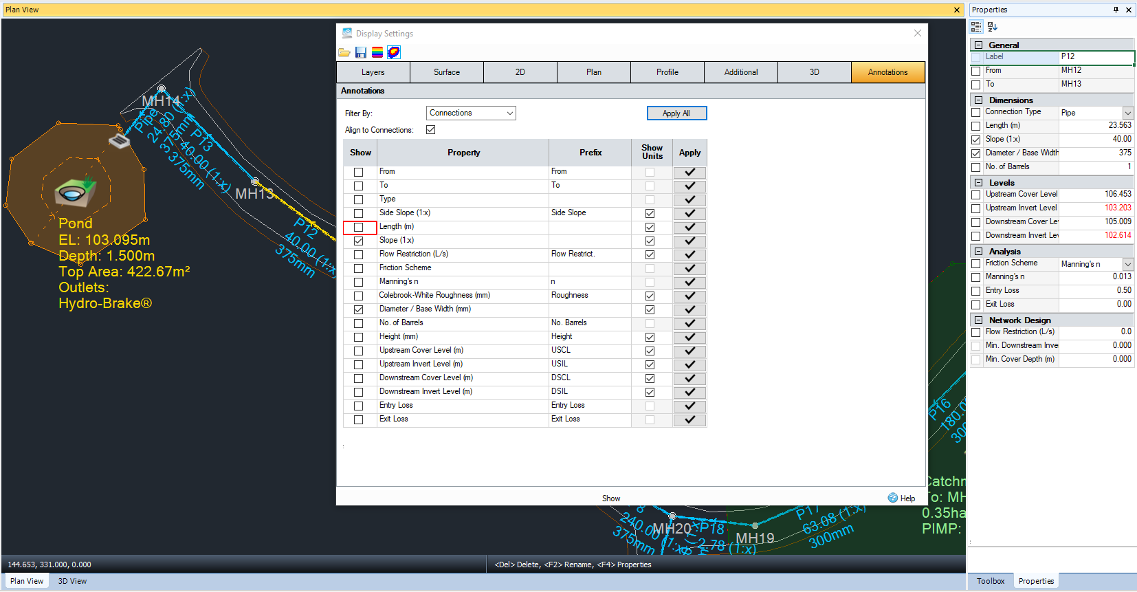
Annotations
Annotate the plan for ease of communication and to reduce additional work producing CAD drawings. Available via Properties and Display Settings the user has flexibility to set specific information relevant to their project as well as prefixes and units as required for ease of submission to regulatory authorities.
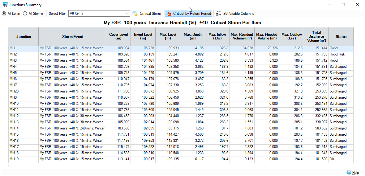
Critical by Return Period Added
Now sort results by Critical by Return Period to view the worst case storm for each rainfall Return Period pairing - e.g. 30 year, 100 year, 100 year plus 30% climate change. This enables easy production of reports to comply with regulatory requirements.
Orbit added to 3D View
For improved ease of use and speed when using the 3D view, an orbit option has been added supported via keyboard and mouse.
Support for Multiple Barrels in 2D / 3D Views
Multiple barrels on pipes and open connection are now shown on 2D and 3D to enable better understanding and communication of a drainage design.
What's New in Version 2021.6
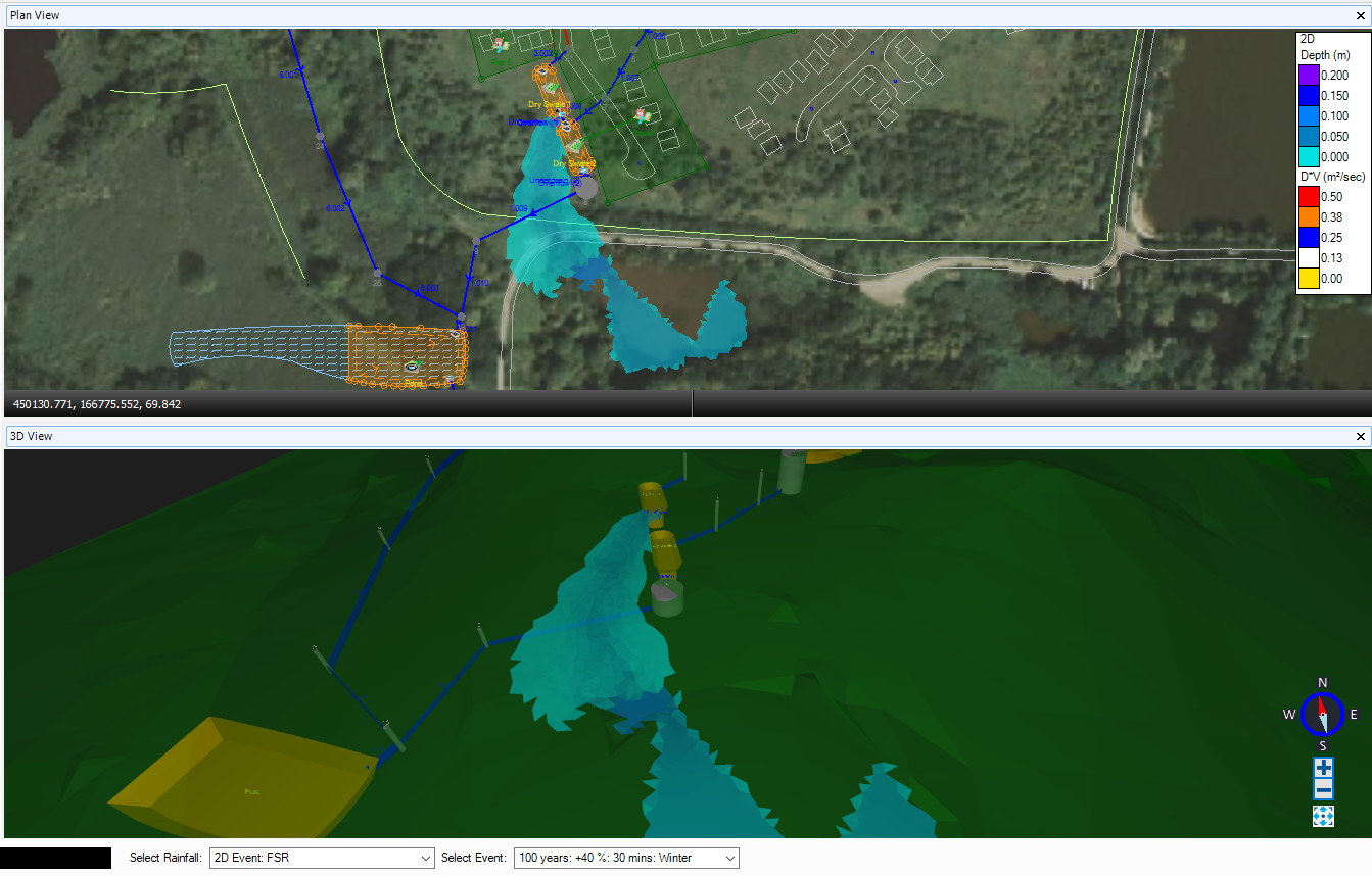
Designing for Exceedance with 1D - 2D Analysis (Premium Tier)
Deliver against requirements to demonstrate overland flow paths for exceedance events using 1D - 2D analysis.
- Confidently use benchmarked, coupled 1D and 2D simulation engines to analyze designs for exceedance events including climate change
- Water is exchanged at manholes, open channels and stormwater controls (SuDS structures) giving confidence in the accurate location of overland flows to determine flood risk
- Decisions refined and automated for design requirements to reduce model setup time
- Extract and communicate graphical representation of overland flow paths to demonstrate compliance with regulatory standards
Improvements to .mdx file Importer
Warnings refined to help existing MicroDrainage users understand the severity and reduced so they are not shown for default values that have no impact.
What's New in Version 2021.5
Deluge Engine Upgrade
The generation of deluge results has been upgraded to a new faster, more accurate 2D engine which enables the support of irregular triangular meshes allowing better identification of flow paths and ponding areas to identify optimal locations for surface water management solutions.
Compatibility with Civil 3D® 2022
InfoDrainage for Civil 3D® is now compatible with Civil 3D® 2022 enabling our customers to work with the latest software update available as recommended by Autodesk.
Analysis with Hydrograph / Base Flows Only
Analysis of hydrographs or baseflows only (without rainfall / inflow areas) is now supported to enable all types of design workflows to be completed without the need to specify dummy rainfall data.
What's New in Version 2021.4
A reminder that a Licensing Update was made in 2021.2, if you did not install this version please note that a new license is required.
Updated and Improved SWMM Engine
The InfoDrainage hydraulic analysis engine has been updated to improve performance when running multiple events. Speed increases will be seen as events are shared across multiple processors, such as when running multiple design rainfall events to identify critical storms for submitting designs for approval. In addition, this latest update also aligns the InfoDrainage SWMM engine with the Innovyze enhanced SWMM engine in InfoWorks ICM with the continued added benefit of hydraulic analysis of LIDs / stormwater controls / SuDS.
Support for Sanitary/Sewer Networks on Export from Civil 3D®
When exporting from Civil 3D® using InfoDrainage for Civil 3D® the network can be set as Sanitary/Sewer or Storm Phase type with round tripping automatically detecting the Phase from the InfoDrainage file. This enables full support for both network types without the need to make additional updates.
What's New in Version 2021.3
A reminder that a Licensing Update was made in 2021.2, if you did not install this version please note that a new license is required.
Support for ReFH 2.3 including Climate Change
InfoDrainage now supports ReFH2.3 model including the option to apply climate change factors to design rainfall when combined with ReFH2 hydrographs and greenfield calculations which allows full regulatory compliance to design for exceedance events.
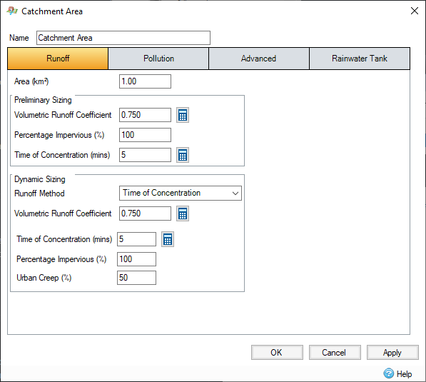
Updated Urban Creep - Catchment Elevation Support
Urban Creep can now be applied globally or per catchment for clear compliance with the Non-statutory technical standards for Sustainable Drainage guidance which includes allowance for urban creep which varies with housing density and type. Urban Creep allows for the design of the drainage system to accommodate expected changes over the lifetime of the proposed development.
What's New in Version 2021.2
Licensing Update (ACTION REQUIRED)
With this latest update and to support our licensing technology in the future it was required that we issue new licenses. The new licenses will work with version 2021.2 onwards only.
Please Note: Your old license will work with versions up to 2021.1 and will continue to work for 30 days to allow installation of the new version and license. After 30 days your old license will cease to work, please contact our support team or your account manager for more information.
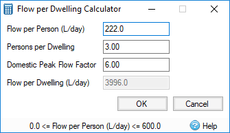
Sanitary Sewer Design
Design Sanitary Sewers using a range of methods with the Network Design Wizard able to size pipes and manholes in accordance with regulatory requirements for speedy approval. Choose from:
- User entered base flows (see more details below)
- EN752 Discharge Units method (including Total Discharge Units Calculator to avoid the need for additional spreadsheets)
- Flow per person or per dwelling per day (Main Drainage Method)
Base Flow
Apply constant flows using the new Base Flow Inflow type for Storm or Sanitary phases. A Base Flow is a simplified input hydrograph.
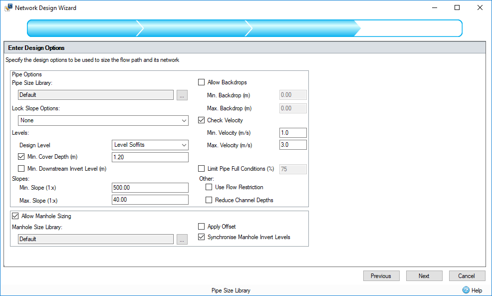
Advanced Pipe Design
In both Sanitary and Storm phases the Network Design Wizard now allows optimal use of Limited Pipe Full Conditions, Maximum Slopes, Backdrops and Minimum Invert Elevations to reduce the need for manual adjustments. With the same ability to review changes and optional commits putting the engineer in control of their design.
Synchronize Manhole and Connection Cover Elevations
Synchronizing the elevations on the Manholes and the Connections. This will mean that if the cover elevation is edited on the Connections form it updates the Manhole, and vice versa.
Select All in Tree View
Select All on Tree View will enable better use of Properties for multi-edits and make it easier to change templates of all of one Object type.
Additional Licensing Improvements
Now enter the network license server in product and choose between different licenses where multiples exist to make it easier to apply and update licenses.
What's New in Version 2021.1
3D Views
Delivering animated phase wide 3D Views for all objects and surfaces as well as individual Stormwater Controls to enable better visualization and interrogation of site design and replicating the true to build nature of sustainable drainage systems. Visually helps to identify errors, incorrect elevations and locations of flooding as well as enable better communication of designs.
- Animate water elevation for selected rainfall event.
- Move around 3D View via keyboard, mouse or with user interface controls.
- Right-click on Plan View or Objects and Zoom to Extents or Selection to center in desired location.
- Views Ribbon to enable setup of optimal windows layout with multiple stored views.
Connected Calculators and Audit Reports
- Link to UK and Ireland Rural Runoff Calculator from the Audit Report to calculate Runoff Rates and Volumes to auto-populate report and remove the need to manually enter values.
Stormwater Control Results Improvements
- Interpret and explain results for Stormwater Controls more easily by automatically seeing the US and DS Depth as well as optionally displaying intermediate depths to demonstrate the passing of water through each Stormwater Control.
- Aids understanding of the behavior of water within Stormwater Controls that slow down the flow to help visually communicate the results with confidence.
What's New in Version 2020.2
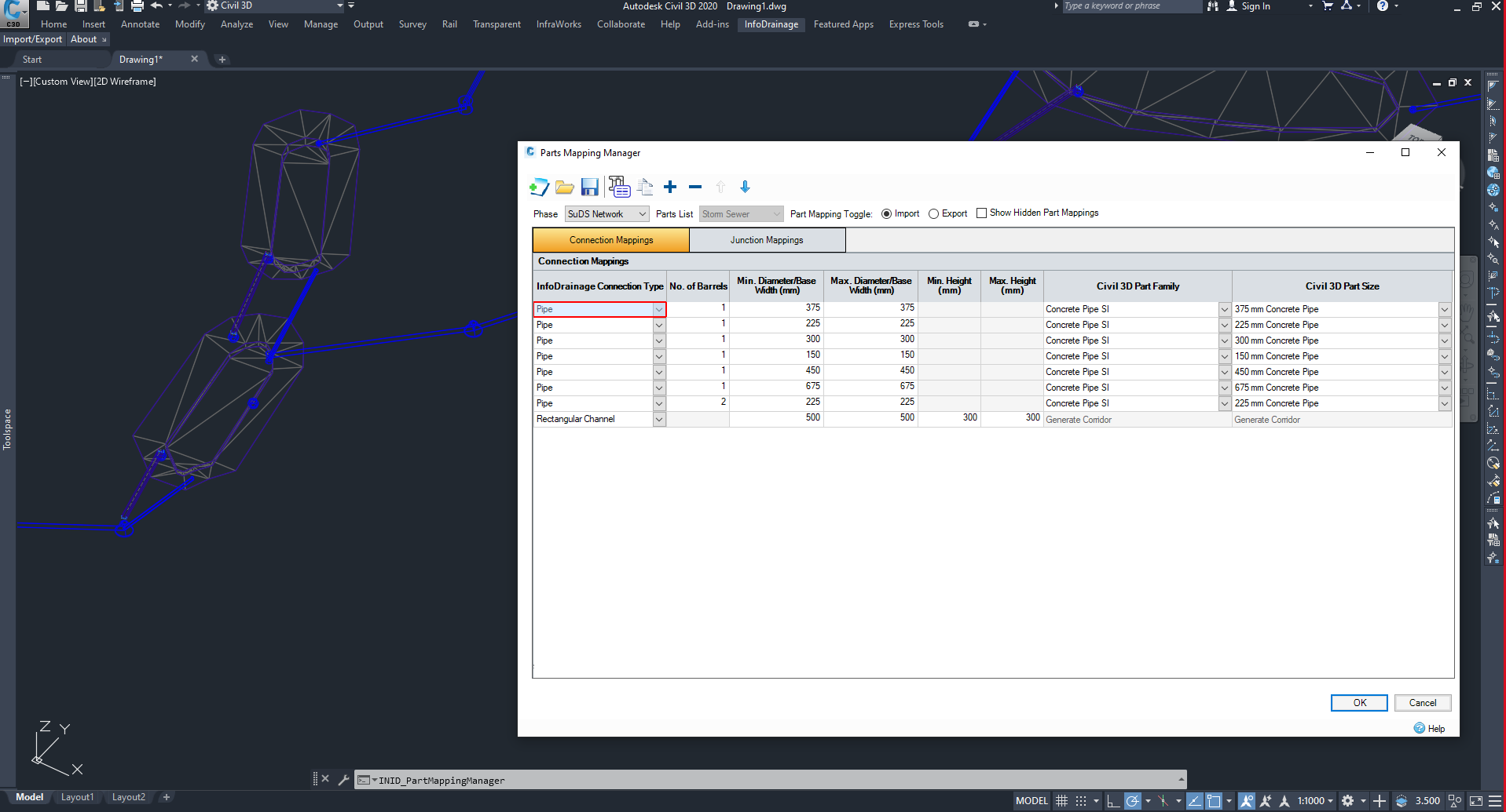
InfoDrainage for Civil 3D®
Plugin for Civil 3D® 2019, 2020, and 2021 allowing import and export of InfoDrainage files within Civil 3D®. This converts InfoDrainage data to and from Civil3D® objects via a parts mapping manager and offers the following benefits:
- Enables better use of Civil 3D® data, streamlining workflows, reducing laborious data entry to provide an efficient drainage design workflow.
- By using parts mapping, this enables faster 3D object representation as required for BIM compliance.
- Once parts mapping is set up, import/export remembers InfoDrainage data ensuring round tripping maintains information when multiple iterations are required.
- Stormwater controls (SuDS structures) are accurately represented in the surface as laid out on plan in InfoDrainage.
- Further design iterations within Civil 3D are minimized by maintaining correct connection, inlet and outlet locations from the graphical plan layout in InfoDrainage.
Installation and Licensing
- This interface is an optional component so is provided as a separate installer that can be installed as required. Refer to Installing InfoDrainage for Civil 3D® for installation instructions.
- Access to InfoDrainage for Civil 3D® is only available at the Advanced Tier and above. You can find more information on InfoDrainage Tiers (Innovyze) or by contacting your account manager.
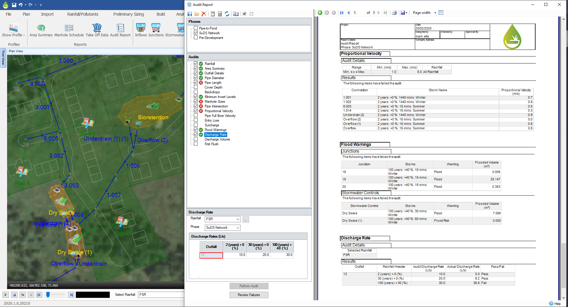
Audit Reports
Create audit reports to check properties of the design and results against a range of criteria. Audits can trigger additional analysis or validate and report missing data required to complete the audit.
- Aids designers and reviewers by collating data required to demonstrate compliance with local regulatory requirements.
- Customizable and stored templates reduce the need to re-enter data and allow quicker submission to multiple authorities with differing requirements.
- If all data and results exist, there is no need for additional analysis.
- Validation and failure review forms allow you to quickly find where improvements are needed in the design to ensure approval is granted quickly.
Properties
Show details of the currently selected item(s) alongside the Plan view allowing values to be changed without visiting the detailed data forms.
- Streamlined views and editing capability without needing to open detailed data forms.
- Much easier to update multiple values at once rather than visiting each data form or using Tables.
- Multiple view options enables user to choose which they find quicker to use.
- Provides familiar view and edit options to CAD and MicroDrainage users.
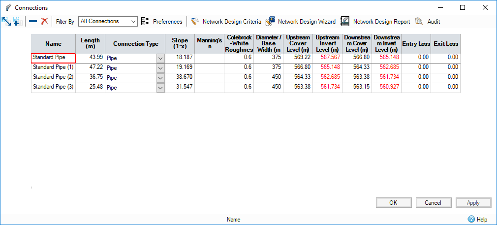
Connection Losses
Entry and Exit Losses added to connections.
- Enables head loss coefficients to be set for more accurate analysis of connections.
- Can be automatically set to meet audit requirements using Review Failures on Audit Report.
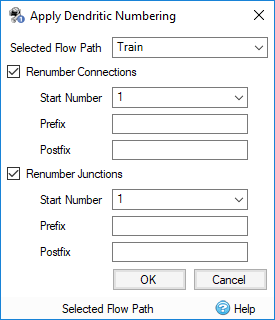
Dendritic Numbering
Allows numbering of connections or junctions along a flow path, including incoming branch lines. Start number, prefix and postfix can be set.
- Saves time manual renumbering of connections and junctions.
- Support for dendritic numbers enables matching against MicroDrainage numbering convention.
Safety Factor (UK Region only)
Reduces the Infiltration Rate during analysis by dividing it by the safety factor, which enables compliance with UK regulation.
Rural Runoff Calculator Improvements (UK Region only)
Redesigned form with additional methods to enable compliance with the latest UK regulatory requirements.
- Addition of ReFH2 method for calculating greenfield rates and volumes.
- Update of FEH QMED equation to 2008 version.
- Redesign of form to support minimum screen resolutions.
What's New in Version 2020.1
Hydraulic LID Updates
Stormwater controls now support backwater analysis enabling accurate and realistic assessment of complex mitigation strategies.
Manhole Design Improvements
- Manhole Sizing as part of the Network Design Wizard including Offsets calculation to producing designs that meet regulatory requirements.
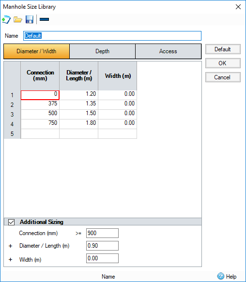
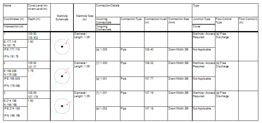
- Manhole Schedule formatted to meet industry standard templates for clear communication with stakeholders and reduced post-processing.
- Setting Out Information allows site origin and orientation to be entered to accommodate site requirements and enable easier to interpret schedules.
- Insert Junction avoids losing connection data and needing to redraw when adding new junctions.
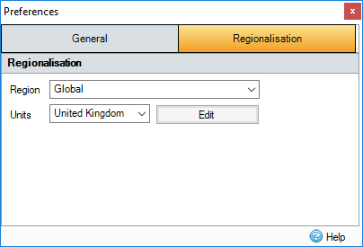
Regionalization
- Regional modes – View software in Global or Regional modes to display only relevant methodologies and calculators giving a cleaner interface for efficient and predicable workflows.
- Project templates – Shareable templates saving reusable settings, object templates and rainfall to avoid setting up data multiple times.
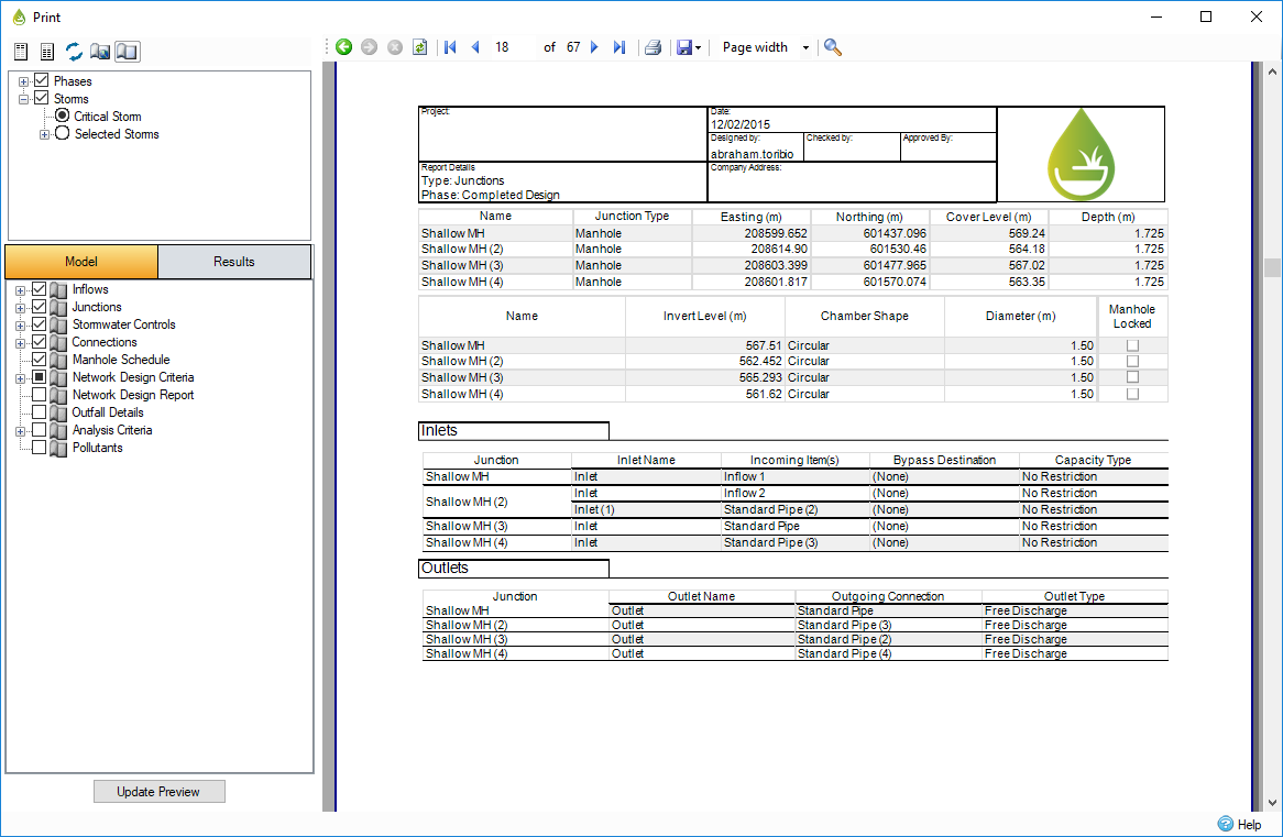
Printing / Reporting Improvements
Improved printing / reporting layout for clearer interpretation of results. Expanded reporting data now included to produce a complete set of print outs.
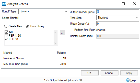
Multiple Rainfall Datasets
Run multiple return periods and different rainfall datasets in one simulation to accommodate all required events in the same analysis enabling easier comparison and identification of critical storms.
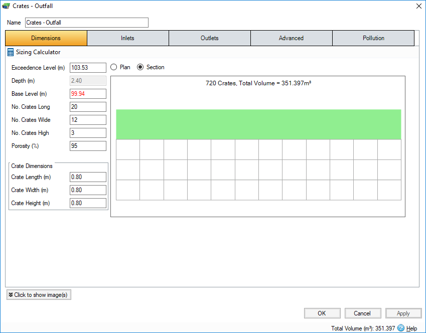
New Stormwater Control - Cellular Storage
Specify crate dimensions and number of crates without the need for manual calculations.
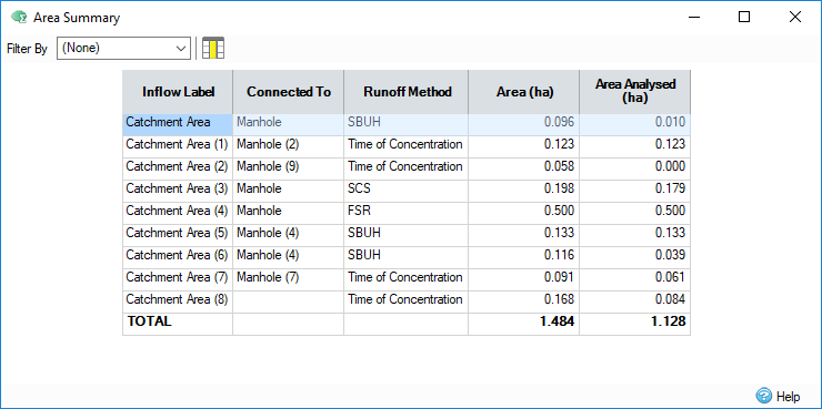
Inflow Summary
Tabular report of all contributing areas that have been analyzed to easily review and report total and impermeable areas.
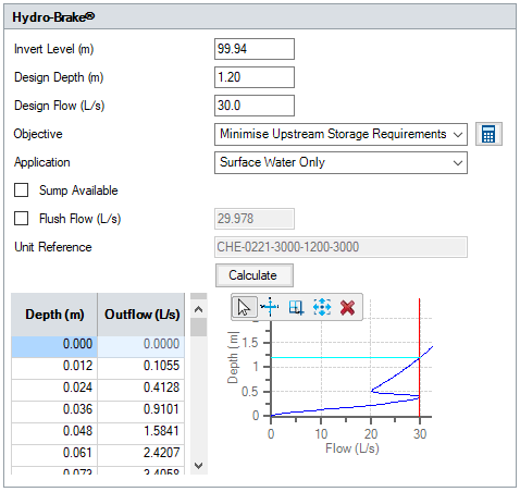
New Outlet - Hydro-Brakes®
Built in calculator to size HydroBrakes® using the Hydro International built in curves for their vortex controls automatically design/size appropriate flow control devices with built in curve data without having to manually populate depth/flow tables.
ReFH2 Unit Hydrograph
UK unit hydrograph methodology now supported to meet UK regulatory requirements to use the latest hydrograph runoff method.
Import / Export MicroDrainage format files
- Import .mdx, .srcx, .casx, .mdsx
- Export .mdx
Enable smooth transition for users working with Industry Standard software to continue with designs or integrate with other packages supporting these formats.
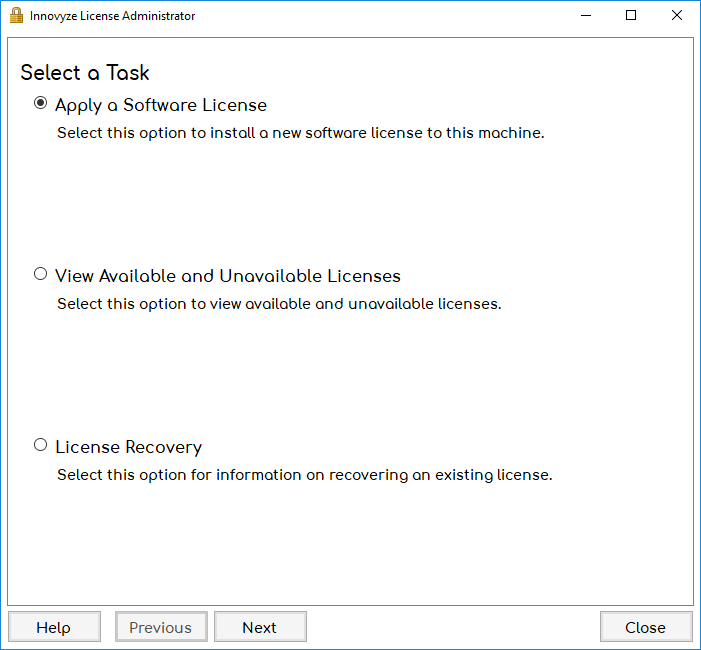
New Licensing Technology
Improved User Experience in applying new licenses and upgrading licenses without the need to exchange files.
What's New in Version 2019.1
Full Hydraulic SWMM5 Simulation Engine with Hydraulic LIDs
Adopting the SWMM5 engine brings you reliable and widely accepted hydraulic analysis of pipes, manholes and unique to XPDrainage, hydraulic LID structures. The analysis is significantly faster than the previous XPDrainage engine saving you time and giving you more confidence in your designs. It also offers more commonality with some of the other Innovyze modelling products that include SWMM5.
Build multiple reports to plot and tabulate results from different phases by total or individual objects enabling quick interpretation of results and aiding decision making when considering different stormwater control options.
Open and closed conduits can be entered by coordinates to extend the range of connections that can be included in a network.
Reduce time editing and correcting mistakes by changing templates on multiple items in one action.
Percentage Impermeable (PIMP)
Match standard UK procedures and more clearly demonstrate compliance to approving authorities.
Increase impermeable areas to model future scenarios in an easy to understand and reportable way.
Auto generate design storms to size pipes and analyze networks based on the most widely accepted rainfall method in China, saving large amounts of time manually entering rainfall events.
Show the reduction in runoff volume compared to rainfall volume in a printable format without the need for manual calculation.
- Introduce backdrops when slopes/velocities exceed maximum values and could be reduced saving manual edits.
- Refresh rational results and re-audit against pipe sizing criteria to view updated catchment data on pipe sizing report without rerunning the wizard.
- Audit pipe sizing criteria against connections to pre-test network before sizing takes place.
- Minimum DS Invert elevation and Cover Depth per connections available and shown on Profile to meet fixed conditions or work with existing network infrastructure.
- Add Network Mode on plan for quicker layout of pipes and manholes.
What's New in Version 2018.2
Automatically calculate inlet capacity using HEC22 Methodology from plan data, analysis results or manual flow entry. Preview gutter size and effectiveness in plan and cross-section view for ease of understanding.
Simplified Modified Rational Method
Available as a Static Analysis option to comply with a variety of US regional runoff requirements to use the Simplified Modified Rational Method triangular hydrograph approach.
Import / Export Text Files (.csv, .xls and .txt)
Save time building networks by communicating with more packages with a variety of text formats. Loads and saves data for Inflows, Junctions, Connections and Stormwater Controls.
Pipe Sizing for Minimal Excavation
Updated Pipe Sizing routine to lay the flattest gradient pipes that meet required criteria will minimize excavation and reduce construction costs. In addition, automatically size to meet max velocity, size pipes downstream of flow controls and include backdrops – all with easily visible warnings summarized to aid engineering adjustments.
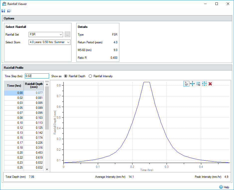
View and Export rainfall before or after analysis to check, edit and reuse rainfall generated in InfoDrainage.
Speed up network editing by using the Profile Summary Table to edit values and see live updates.
Update Elevations from New Surface Data
Avoid manual data entry by automatically updating cover elevations when a new surface is loaded. With user entered data optionally maintained.
Rainfall IDF Table Supports NOAA ATLAS 14 File Format
Comply with US Requirements to use the latest rainfall database.
Comply with UK Requirements to use the latest rainfall database.
What's New in Version 2018.1
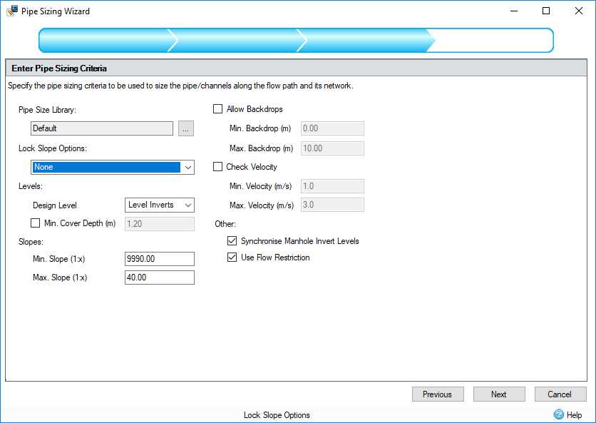
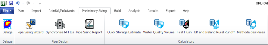
Preliminary Pipe Sizing. Step more easily through the steps needed to complete the preliminary pipe sizing part of your stormwater design. Use this as the first step to sizing before running full analysis. Or stop here and submit your pipe sizing report for approval.
Preliminary Sizing Ribbon. Find all the tools for your preliminary pipe sizing in one place to save time navigating between different parts of the software.
Pipe Sizing Wizard. Step through setting up Pipe Sizing Criteria, reviewing proposed changes and producing a full Pipe Sizing Report quickly and easily.
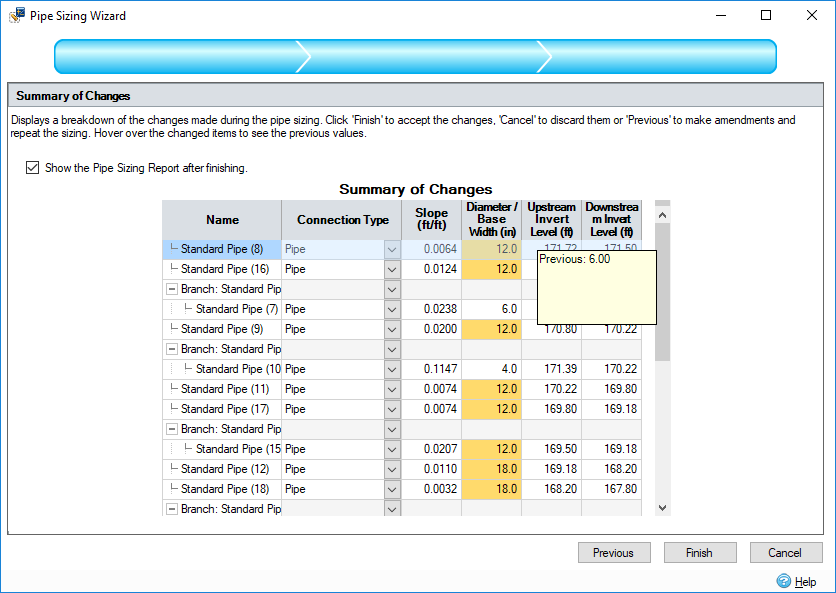
More Pipe Sizing Options. To reduce the number of manual changes needed minimum and maximum gradients for different pipe sizes and fixed slopes have been added to the sizing options.
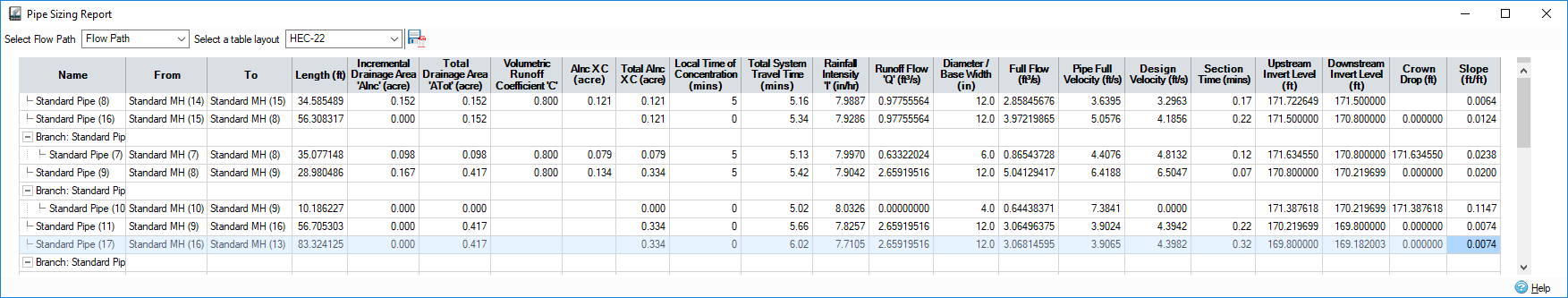
Pipe Sizing Report. Quickly view and output rational method pipe sizing reports in standard HEC-22 format or customizable, reusable layouts to meet local requirements.
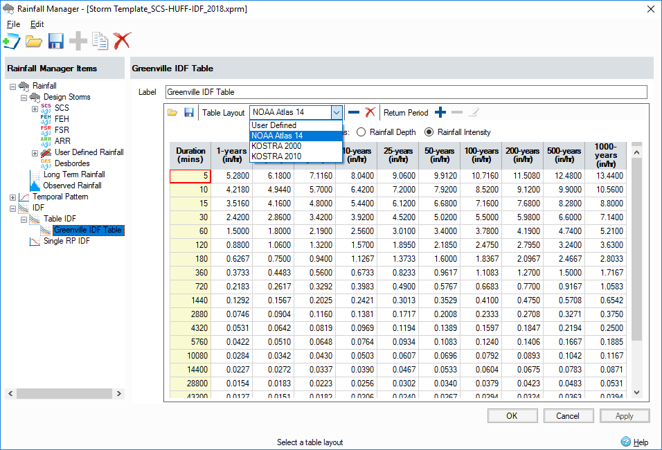
IDF Table. Now set up multiple return periods / average recurrence interval IDF tables instead of individual rainfall collections. Use our pre-populated templates for NOAA Atlas 14, KOSTRA 2000 and KOSTRA 2010 IDF Data or create, save and re-use custom templates for your region.
Extended Preliminary Sizing Options. Setup separate preliminary sizing (rational method) and dynamic analysis options in the same catchment areas to take account of different methodologies available.
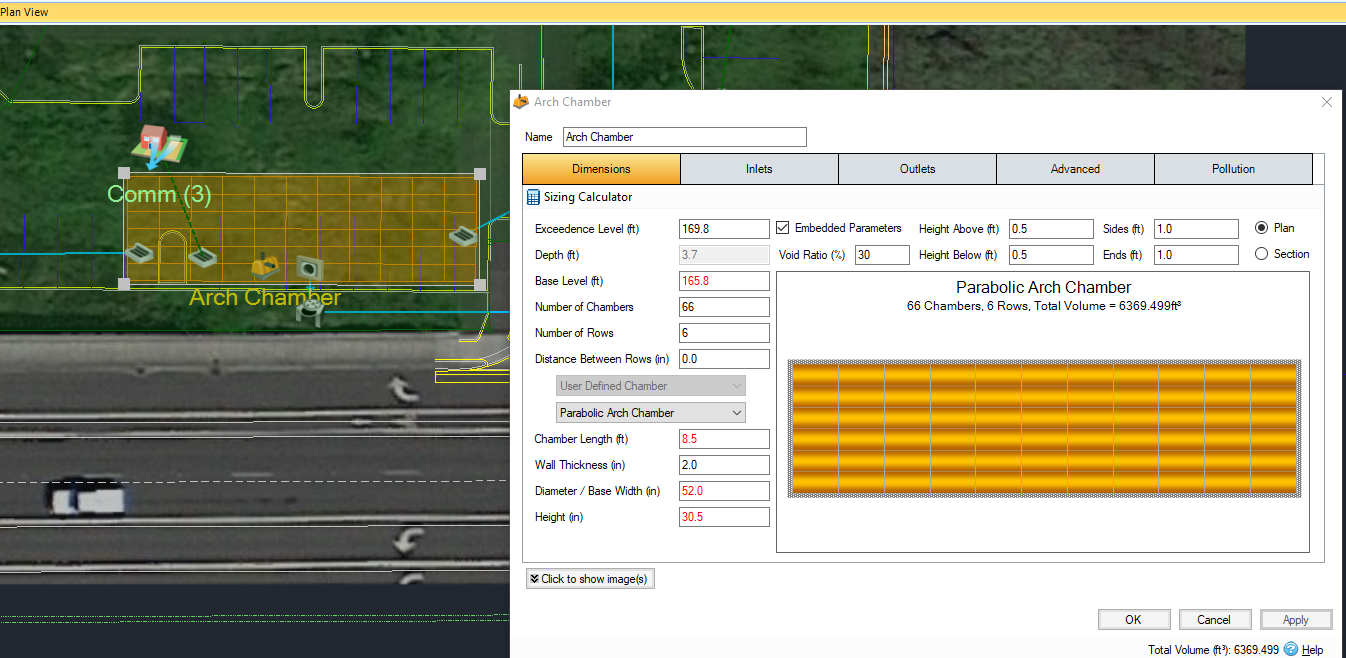
NEW Chamber Stormwater Control. Quickly layout Arch, Circular and Rectangular chambers or create and reuse custom chambers for stormwater storage. Visually see them laid out on plan with export to CAD and GIS options available.
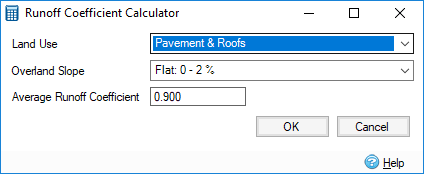
Rational Method Cv Calculator. Using widely used tables of suggested runoff coefficients this built in calculator speeds up defining catchment characteristics. Local guidelines may differ from the calculator values and where values differ the locally recommended values should be used.
Seasonal Cv Values. Required in the UK by the Wallingford Procedure with FSR and FEH rainfall methods, summer and winter Cv values can be used to enable one simulation to run all storms required for design.
Additional Pipe Roughness. Now choose between Colebrook-White pipe roughness coefficient or Manning’s n values to suit your local guidelines and requirements.
What's New in Version 2017.3
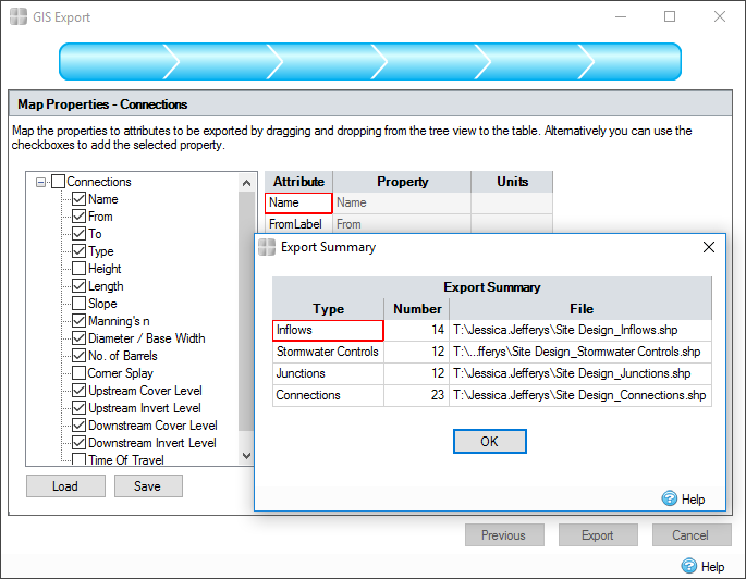
GIS Export Wizard
You can now export a full design or individual elements, the layout and design parameters in a format of your choice to better record and communicate asset data. Remember the format used to save time in the future when communicating with multiple authorities.
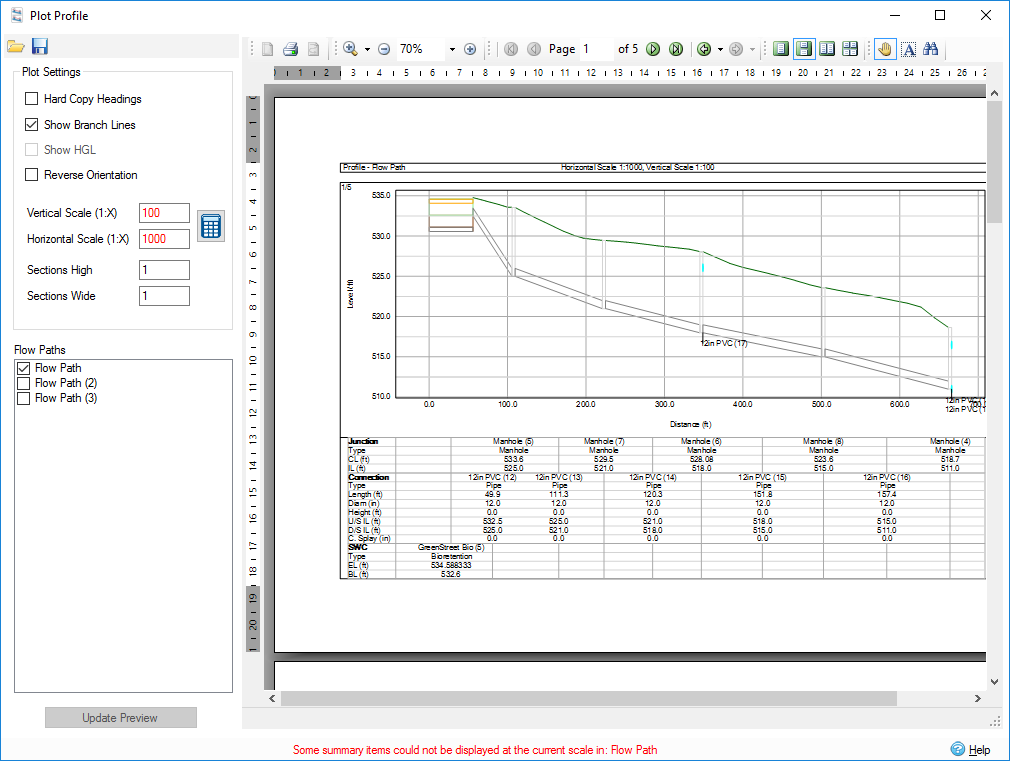
Plot Profile and CAD Export
Print scaled plots of longsection profiles to be used on site or export to CAD for inclusion in final drawings providing the next step towards building a drainage design.
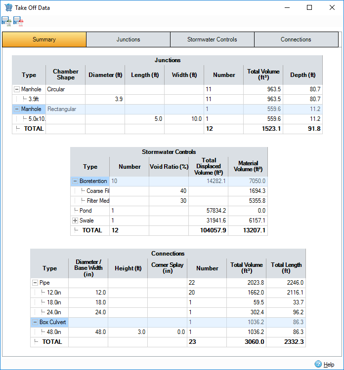
Take Off Data
In overall system Summary format, or detailed for Junctions, Connections or Stormwater Control data, a volume and dimension report can be produced as a step towards costing your project. See totals for manhole and pipe types or on an individual basis. Export to Excel or PDF to include in reporting or complete costing information.
Box Culvert
Connections options expanded to include box culverts with or without splay at the corners for structural support.
Synchronize Manhole Invert Elevations
Save time editing network details by synchronizing all manhole elevations to bring them in line with pipe inverts in the click of a button.
What's New in Version 2017.2
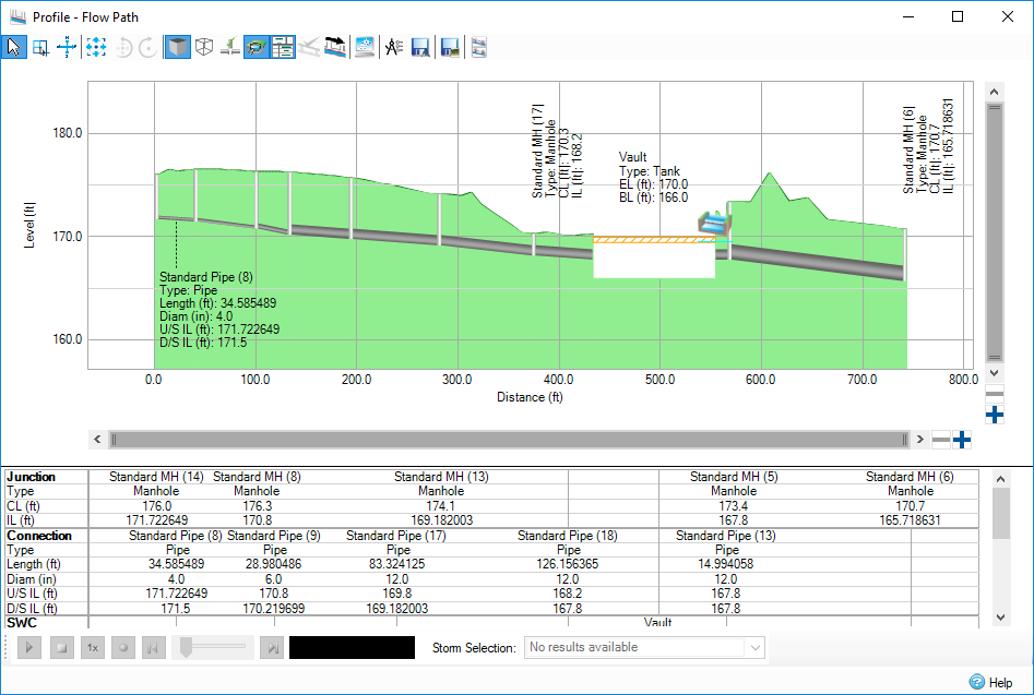
Huge Profile Revamp - Fully compatible with zoom and pan functions the new flexible representation of the drainage network in profile view makes it easy to spot mistakes, visualize the HGL and export to CAD for completed drawings needed on site.
Robust GIS Import - Build models more quickly by importing inflows, connections, junctions and stormwater controls and mapping recorded parameters in an easy to use wizard. Save the mapping format for future use. Provides support for the most common local authority data format.
SBUH Runoff Method (USA) - You can now meet local requirements where SBUH is required.
Variable Outfall Matrix - Easily enter complicated matrices of variable outfall data per storm event for situations where the outfall elevation varies through different rainfall events. With easy storage of data this setup saves hours of individual runs and results extraction and avoids multiple files.
Welcome Screen - Easier to get started with software with all the features you would expect.